IMAGES TAKEN NEAR TO
Ollerton Road, LONDON, N11 2LA
Introduction
This page details the photographs taken nearby to Ollerton Road, N11 2LA by members of the Geograph project.
The Geograph project started in 2005 with the aim of publishing, organising and preserving representative images for every square kilometre of Great Britain, Ireland and the Isle of Man.

There are currently over 7.5m images from over14,400 individuals and you can help contribute to the project by visiting https://www.geograph.org.uk
Image Map
Images are licensed for reuse under creativecommons.org/licenses/by-sa/2.0
Notes
- Clicking on the map will re-center to the selected point.
- The higher the marker number, the further away the image location is from the centre of the postcode.
Image Listing (91 Images Found)
Images are licensed for reuse under creativecommons.org/licenses/by-sa/2.0
Image
Details
Distance
1
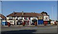
Parade of shops, Bowes Road
Most as of these shop units appear to be empty, hardly surprising given their proximity to the ever-busy North Circular Road.
Image: © Jim Osley
Taken: 23 Jul 2014
0.06 miles
2
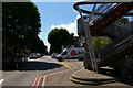
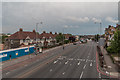
Looking up Ollerton Road
On the right, the end of the footbridge over the North Circular Road.
Image: © Christopher Hilton
Taken: 17 Aug 2017
0.08 miles
3
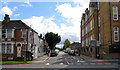
Highworth Road
To the right is Bowes Primary School which was rated as "Outstanding" by OFSTED when inspected in 2013.
Image: © Andrew Tatlow
Taken: 23 Aug 2015
0.09 miles
5
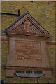
Foundation plaque, Bowes School, Bowes Road
This school, originally the Bowes Road School, was founded in 1900 by the school board for the borough of Southgate, and opened in 1901. It has undergone various reorganisations affecting the age-groups for which it caters; it is currently a primary school with a nursery attached.
See https://en.wikipedia.org/wiki/Bowes_Primary_School for more details.
Image: © Christopher Hilton
Taken: 17 Aug 2017
0.10 miles
6
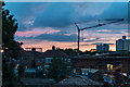
Construction adjacent to North Circular Road (A406), London N11
Looking west, we have a view of the tower blocks adjacent to the Piccadilly Line at Arnos Grove and the gasometer on the corner of Station Road, N11, as well as the construction site..
Image: © Christine Matthews
Taken: 20 May 2014
0.10 miles
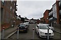
7
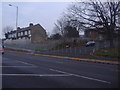
Junction of Pevensey Road and the North Circular Road
This stretch has just been widened in late 2011 and as a result decided to shut off Pevensey Road in the process. The whole row of houses from these to the junction of Bounds Green Road was bought by the council for widening and then sold back by mayor Ken Livingstone when he arrived in 2003. Some appear to be occupied further along but these may well be refurbished once the work is completely finished.
Image: © David Howard
Taken: 31 Jan 2012
0.10 miles
8
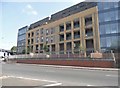
New flats on the North Circular Road, Bounds Green
They extend from here east to around the Brownlow Road junction along parts of the road in between the old buildings.
Image: © David Howard
Taken: 26 May 2018
0.10 miles
9
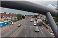
Looking East from the Footbridge over North Circular Road (A406), London N11
Image: © Christine Matthews
Taken: 20 May 2014
0.10 miles
10
Looking East from the Footbridge over North Circular Road (A406), London N11
Image: © Christine Matthews
Taken: 20 May 2014
0.10 miles