IMAGES TAKEN NEAR TO
Ryhope Road, LONDON, N11 1DP
Introduction
This page details the photographs taken nearby to Ryhope Road, N11 1DP by members of the Geograph project.
The Geograph project started in 2005 with the aim of publishing, organising and preserving representative images for every square kilometre of Great Britain, Ireland and the Isle of Man.

There are currently over 7.5m images from over14,400 individuals and you can help contribute to the project by visiting https://www.geograph.org.uk
Image Map
Images are licensed for reuse under creativecommons.org/licenses/by-sa/2.0
Notes
- Clicking on the map will re-center to the selected point.
- The higher the marker number, the further away the image location is from the centre of the postcode.
Image Listing (127 Images Found)
Images are licensed for reuse under creativecommons.org/licenses/by-sa/2.0
Image
Details
Distance
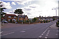
2
Waterfall Road
Looking down into the valley of Pymmes Brook. The road on the right is Ravenscraig Road and the one on the left is Ryhope Road.
Image: © Martin Addison
Taken: 25 Sep 2009
0.11 miles
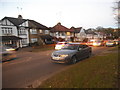
5
Brunswick Park Road, London N11
Looking down Brunswick Park Road we can see Marshalls Close on the left. Falkland Avenue is on the right.
Image: © Christine Matthews
Taken: 9 Apr 2008
0.12 miles
7
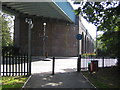
New Southgate: Piccadilly Line viaduct
The viaduct, which was completed in 1933 to enable the extension of the Piccadilly Line to Cockfosters, crosses the A1003 Waterfall Road here.
Image: © Nigel Cox
Taken: 6 Sep 2006
0.13 miles
8
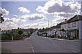
Brunswick Park Road, London N11
Looking down Brunswick Park Road in the direction of Betstyle Circus. The junction of Falkland Avenue is on the right and Marshalls Court on the left.
Image: © Christine Matthews
Taken: 9 Apr 2008
0.14 miles
9
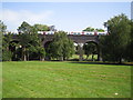
Arnos Park: Piccadilly Line viaduct
This viaduct carries the underground Piccadilly Line railway over the valley of Pymme's Brook. It was completed in 1933 when the line was extended beyond Arnos Grove station. A northbound train for the terminus at Cockfosters is crossing.
Image: © Nigel Cox
Taken: 6 Sep 2006
0.14 miles
10

Snow Covered Oak Tree, Arnos Park, London N11
This is the section of the park west of the viaduct.
Image: © Christine Matthews
Taken: 21 Jan 2013
0.15 miles