IMAGES TAKEN NEAR TO
Jays Street, LONDON, N1 0FE
Introduction
This page details the photographs taken nearby to Jays Street, N1 0FE by members of the Geograph project.
The Geograph project started in 2005 with the aim of publishing, organising and preserving representative images for every square kilometre of Great Britain, Ireland and the Isle of Man.

There are currently over 7.5m images from over14,400 individuals and you can help contribute to the project by visiting https://www.geograph.org.uk
Image Map (Loading...)


Getting Data...Please wait
Leaflet Map data © OpenStreetMap
Images are licensed for reuse under creativecommons.org/licenses/by-sa/2.0
Notes
- Clicking on the map will re-center to the selected point.
- The higher the marker number, the further away the image location is from the centre of the postcode.
Image Listing (306 Images Found)
Images are licensed for reuse under creativecommons.org/licenses/by-sa/2.0
Image
Details
Distance
5
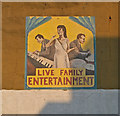
Mural, Copenhagen Street, Islington
Painted on the wall of a building formerly occupied by a public house.
Image: © Jim Osley
Taken: 20 Apr 2011
0.05 miles
6

Mosaic, Thornhill Bridge Community Garden
Image: © Jim Osley
Taken: 20 Nov 2013
0.06 miles
7
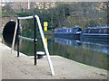
Regent's Canal, Pentonville
Just to the east of Caledonian Road the canal plunges into the 960 yard Islington Tunnel carrying it under the high ground on which Islington High Street was built. A route is signposted for cyclists to take them over the top to the eastern portal.
Image: © Stephen McKay
Taken: 4 Dec 2009
0.06 miles
8
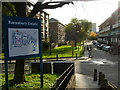
Barnsbury Estate
Work on the Barnsbury Estate, to the east of Caledonian Road, was begun in 1936 by the London County Council, and completed in the 1950s. It comprises 646 housing units in 25 blocks.
Image: © Stephen McKay
Taken: 29 Nov 2007
0.06 miles
9

Pathway between All Saints Church and the Regent's Canal
Image: © John Salmon
Taken: 9 May 2011
0.06 miles
10

Regent's Canal, King's Cross
Light can be seen at the other end of the 960yd long Islington Tunnel, seen here from close to the Caledonian Road bridge. The name of the tug-style narrowboat, 'Russia', is intriguing.
Image: © Stephen McKay
Taken: 29 Nov 2007
0.06 miles