IMAGES TAKEN NEAR TO
Woodland Rise, LONDON, N10 3UJ
Introduction
This page details the photographs taken nearby to Woodland Rise, N10 3UJ by members of the Geograph project.
The Geograph project started in 2005 with the aim of publishing, organising and preserving representative images for every square kilometre of Great Britain, Ireland and the Isle of Man.

There are currently over 7.5m images from over14,400 individuals and you can help contribute to the project by visiting https://www.geograph.org.uk
Image Map (Loading...)


Getting Data...Please wait
Leaflet Map data © OpenStreetMap
Images are licensed for reuse under creativecommons.org/licenses/by-sa/2.0
Notes
- Clicking on the map will re-center to the selected point.
- The higher the marker number, the further away the image location is from the centre of the postcode.
Image Listing (70 Images Found)
Images are licensed for reuse under creativecommons.org/licenses/by-sa/2.0
Image
Details
Distance
1
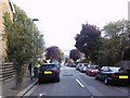
Panorama at the end of Woodland Rise
Looking east.
Image: © Robert Lamb
Taken: 26 Sep 2010
0.05 miles
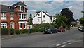
2
Through the houses towards Alexandra Palace
The houses are on Woodland Rise, N10.
Image: © Robin Webster
Taken: 19 Mar 2011
0.08 miles
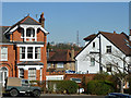
3
Houses at junction of Woodland Gardens and Woodland Rise
I detect a distinctly sylvan theme to the road naming around here...
Image: © David Martin
Taken: 25 Jun 2015
0.08 miles
5
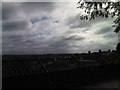
View of London from the viaduct on Parkland Walk #5
With the fencing on the viaduct in shot, looking south-southeast.
Image: © Robert Lamb
Taken: 26 Sep 2010
0.11 miles
6
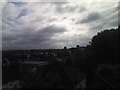
View of London from the viaduct on Parkland Walk #3
This is a pan east of Image, looking south-southeast.
Image: © Robert Lamb
Taken: 26 Sep 2010
0.11 miles
7
View of London from the viaduct on Parkland Walk #2
This is a pan east of Image, looking south-southeast.
Image: © Robert Lamb
Taken: 26 Sep 2010
0.11 miles
9
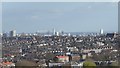
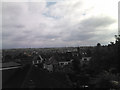
View from St James's Lane Viaduct
This is the view across London from St James's Lane Viaduct on the Parkland Walk. Storm Freya had cleared the air. The ArcelorMittal Orbit Tower and the buildings around Stratford are slightly left of centre.
The Parkland Walk is the former track of the branch railway line which ran from Finsbury Park to Alexandra Palace and closed to passengers in 1954 and finally in 1971. The Parkland Walk officially opened in 1984.
The first part of the Parkland Walk goes from Finsbury Park to Archway Road. The old track of the railway then passes through Highgate Wood before it is rejoined at Muswell Hill Road and heads to Alexandra Palace across St James's Lane Viaduct.
Image: © Marathon
Taken: 11 Mar 2019
0.11 miles
10
Going back to my roots
It's always good when people have an appropriate name for their jobs.
Image: © David Howard
Taken: 15 Jun 2019
0.12 miles