IMAGES TAKEN NEAR TO
Muswell Hill Road, LONDON, N10 3NG
Introduction
This page details the photographs taken nearby to Muswell Hill Road, N10 3NG by members of the Geograph project.
The Geograph project started in 2005 with the aim of publishing, organising and preserving representative images for every square kilometre of Great Britain, Ireland and the Isle of Man.

There are currently over 7.5m images from over14,400 individuals and you can help contribute to the project by visiting https://www.geograph.org.uk
Image Map
Images are licensed for reuse under creativecommons.org/licenses/by-sa/2.0
Notes
- Clicking on the map will re-center to the selected point.
- The higher the marker number, the further away the image location is from the centre of the postcode.
Image Listing (151 Images Found)
Images are licensed for reuse under creativecommons.org/licenses/by-sa/2.0
Image
Details
Distance
1
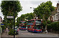
Muswell Hill Road
The road is well lined on both sides by pollarded Plane trees. Metroline bus TE671 collects a female passenger from the stop by Church Crescent - her odd stance is because she is pushing a buggy onto the bus. Behind, TP48 waits on the 603 route. It has finished its runs for the day and is heading back to the depot.
Image: © Martin Addison
Taken: 14 Aug 2009
0.02 miles
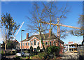
2
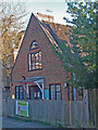
Friends Meeting House, Muswell Hill
Built in the 1920s to the designs of Quaker architect Frederick Rowntree.
Image: © Jim Osley
Taken: 15 Mar 2017
0.05 miles
4
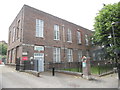
Muswell Hill Telephone Exchange (1)
Situated in Grand Avenue, this TE, which has the code LNMUS, would appear to date from the 1930s like several others in Greater London. It provides telephone and broadband services to 16,296 residential and 783 non-residential premises in Muswell Hill plus Colney Hatch, Cranley Gardens and Fortis Green nearby. The wording "TELEPHONE EXCHANGE" can be seen above the grey doors to the left of the building. Also, the notices adjacent to the doors say "No parking in front of these gates" and "No parking in this area", the latter being on a red background.
Image: © David Hillas
Taken: 9 Jul 2016
0.06 miles
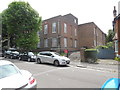
5
Building at the old hospital
The former St Luke's Hospital is now a construction site.
A few of the nicer old buildings have been retained.
Image: © Des Blenkinsopp
Taken: 2 Feb 2016
0.07 miles
6
Muswell Hill Telephone Exchange (2)
This photo shows the TE in Grand Avenue N10 3AY, with trees to the left. It used to have HIGhgate Wood and TUDor numbers until the late 1960s. Now it has 0208- 444, 883 xxxx, plus other Outer London numbers. Incidentally, HIGhgate Wood was the first all-electronic TE in Great Britain in the early 1960s, but following trials that took place, the electronic equipment was taken out in the mid 1960s. Now this TE has System X digital equipment as do other TEs throughout the country. Incidentally, the notice in red on the gates says "No parking in this area" although a large white car is parked in front of those same gates.
Image: © David Hillas
Taken: 9 Jul 2016
0.07 miles
7
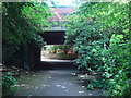
Bridge carrying the B550 Muswell Hill Road over Parkland Walk
Image: © Oxyman
Taken: 29 Apr 2009
0.07 miles
8
Muswell Hill Road Bridge
The bridge carries Muswell Hill Road over the dismantled Alexandra Palace Branch of the Great Northern Railway. Through the bridge, where houses and St.James' school now stand, is the site of Cranley Gardens Station. The track bed has been turned into the 'Parkland Walk'. Information about and photos of the old Cranley Gardens station can be found at http://www.disused-stations.org.uk/c/cranley_gardens/index.shtml .
Image: © Martin Addison
Taken: 22 May 2007
0.07 miles
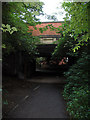
9
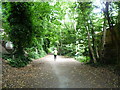
The Parkland Walk near Muswell Hill Road
The Parkland Walk follows part of the Edgware, Highgate & London Railway. The line from Finsbury Park to Highgate and on to Edgware opened in 1867, and a branch from Finchley to High Barnet opened in 1872. The branch from Highgate to Alexandra Palace (which followed the route here) opened in 1873. In the 1930s it was proposed to transfer all the lines to become part of London Transport's Northern line. The section from Highgate to High Barnet and Mill Hill were transferred in 1940. Although partly completed, the rest of the scheme was halted and then abandoned after the Second World War. Infrequent passenger trains continued to Alexandra Palace but these ceased in 1954. Some freight trains ran until 1964 and the last use was by London Transport for the transfer of some Tube trains until 1970.
Cranley Gardens station was just behind where I am standing, on the other side of Muswell Hill Road. See http://www.disused-stations.org.uk/c/cranley_gardens/ for more information about Cranley Gardens station and the line to Alexandra Palace.
Schemes to use the land were developed by the neighbouring Boroughs, and all included a Walk. The Parkland Walk has now become London's longest nature reserve. It was officially opened in 1984.
Image: © Marathon
Taken: 17 Jun 2015
0.08 miles
10
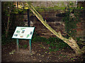
Parkland Walk Information
Information board beside the dismantled Alexandra Palace Branch. The lower part of the fence in the background is constructed of old railway sleepers.
Image: © Martin Addison
Taken: 22 May 2007
0.08 miles