IMAGES TAKEN NEAR TO
Castlehill Crescent, HAMILTON, ML3 7TZ
Introduction
This page details the photographs taken nearby to Castlehill Crescent, ML3 7TZ by members of the Geograph project.
The Geograph project started in 2005 with the aim of publishing, organising and preserving representative images for every square kilometre of Great Britain, Ireland and the Isle of Man.

There are currently over 7.5m images from over14,400 individuals and you can help contribute to the project by visiting https://www.geograph.org.uk
Image Map (Loading...)


Getting Data...Please wait
Leaflet Map data © OpenStreetMap
Images are licensed for reuse under creativecommons.org/licenses/by-sa/2.0
Notes
- Clicking on the map will re-center to the selected point.
- The higher the marker number, the further away the image location is from the centre of the postcode.
Image Listing (15 Images Found)
Images are licensed for reuse under creativecommons.org/licenses/by-sa/2.0
Image
Details
Distance
1
French influence in Hamilton produces difficult name, Chatelherault
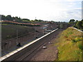
Once upon a time there was a railway station just north of here called Ferniegair, after a small village on the A72 road. It was moved slightly south in 1876 so that it could be served by trains from the Larkhall direction towards both Hamilton and Motherwell. It was one of numerous stations closed as a wartime economy in 1917 but, unlike most others temporarily closed in the same period, it never re-opened, though passenger trains continued to pass by until 1965. When the Larkhall was line was re-opened in 2005 it was decided to locate a station here but instead of calling it Allanton after the nearest village it was given the almost unpronounceable name of Chatelherault after the country park west of the A72. Here the station is under construction. The photograph is taken from Clyde Avenue bridge shortly before its demolition and replacement by the new Allanton approach road and bridge seen in the background.
Image: © A-M-Jervis
Taken: 13 Aug 2005
0.17 miles
3
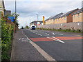
National Cycle Route 74 in Ferniegair
At an uncontrolled crossing point on Carlisle Road where the route continues on the other pavement.
Image: © wrobison
Taken: 14 Sep 2020
0.18 miles
4
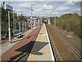
Chatelherault railway station, Lanarkshire
A station called Ferniegair originally stood here between 1866 and 1917 on the Caledonian Railway's line from Motherwell to Coalburn, surrounded by coal-mines. The station was rebuilt and reopened in 2005 by Network Rail on the reopened branch from Hamilton to Larkhall.
The scenery has changed out of all recognition from the original. The mines are gone and the station adjoins a country park. View north west towards Hamilton and Glasgow.
Image: © Nigel Thompson
Taken: 15 Apr 2014
0.18 miles
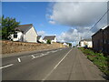
7
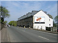
Allanton Terrace on Larkhall to Hamilton Road
Image: © Iain Thompson
Taken: 6 May 2006
0.21 miles
10
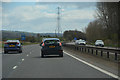
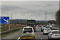
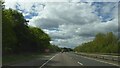
South Lanarkshire : The M74 Motorway
Looking along the M74 motorway.
Image: © Lewis Clarke
Taken: 25 Apr 2016
0.22 miles