IMAGES TAKEN NEAR TO
Cormiston Road, BIGGAR, ML12 6FF
Introduction
This page details the photographs taken nearby to Cormiston Road, ML12 6FF by members of the Geograph project.
The Geograph project started in 2005 with the aim of publishing, organising and preserving representative images for every square kilometre of Great Britain, Ireland and the Isle of Man.

There are currently over 7.5m images from over14,400 individuals and you can help contribute to the project by visiting https://www.geograph.org.uk
Image Map (Loading...)


Getting Data...Please wait
Leaflet Map data © OpenStreetMap
Images are licensed for reuse under creativecommons.org/licenses/by-sa/2.0
Notes
- Clicking on the map will re-center to the selected point.
- The higher the marker number, the further away the image location is from the centre of the postcode.
Image Listing (53 Images Found)
Images are licensed for reuse under creativecommons.org/licenses/by-sa/2.0
Image
Details
Distance
1
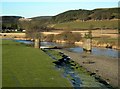
The River Clyde
Looking downstream from the end of Wolfclyde Bridge. For more information about the old railway bridge and line, see Image
Image: © Mary and Angus Hogg
Taken: 10 Dec 2008
0.06 miles
2
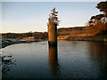
View 'across' the former Wolfclyde Viaduct
These piers are all that remain of a 110 metre-long railway viaduct which was built in 1858-60 to carry the Symington, Biggar and Broughton Railway over the River Clyde.
The line was subsequently acquired by the Caledonian Railway in 1861, with the line extended to Peebles in 1864, and eventually closed by 1966 (having closed to passengers in 1950).
Image: © Alan O'Dowd
Taken: 20 May 2020
0.06 miles
3
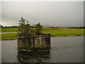
Remains Of Coulter Viaduct
The viaduct supports are all that remain, both in the River Clyde and across the adjacent floodplain. For a photograph of the viaduct in March 1966, refer to http://www.railbrit.co.uk/imageenlarge/imagecomplete.php?id=6450 This viaduct was on the route of the Symington, Biggar and Broughton Railway which closed in April 1966.
An incoming prolonged blustery shower heads towards the scene, enveloping Tinto in the background.
Image: © James T M Towill
Taken: 24 Dec 2014
0.06 miles
4
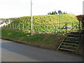
Former Railway Bridge Supports on the River Clyde
The bridge carried the former Symington to Biggar railway across the River Clyde.
Image: © G Laird
Taken: 20 Sep 2013
0.06 miles
5
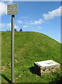
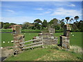
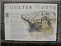
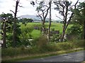
Coulter Motte Hill
Built in the 12th century.
Image: © adam sommerville
Taken: 11 Sep 2009
0.07 miles
6
Coulter Motte
Mottes were common features of the Scottish landscape in the 12C. They were fortified residences of feudal lords, and centres of local administration. On the flat top would have been a timber and clay building, protected by a timber palisade. Only the mound remains, the encircling ditch has been filled in, and there is no trace of bailey, courtyard, stables, brewhouse, bakery and other buildings.
Image: © M J Richardson
Taken: 18 Mar 2008
0.07 miles
8
Coulter Motte Hill information point
Image: © adam sommerville
Taken: 11 Sep 2009
0.07 miles
9
Remains of the railway bridge seen from the Motte Hill
Image: © Elliott Simpson
Taken: 30 Jul 2011
0.07 miles
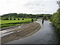
10
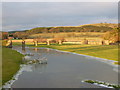
Old viaduct pillars, Wolfclyde
Viewed over a field with frozen over floodwater from the River Clyde.
Image: © Alan O'Dowd
Taken: 26 Dec 2013
0.07 miles