IMAGES TAKEN NEAR TO
Douglas, LANARK, ML11 9PA
Introduction
This page details the photographs taken nearby to ML11 9PA by members of the Geograph project.
The Geograph project started in 2005 with the aim of publishing, organising and preserving representative images for every square kilometre of Great Britain, Ireland and the Isle of Man.

There are currently over 7.5m images from over14,400 individuals and you can help contribute to the project by visiting https://www.geograph.org.uk
Image Map
Images are licensed for reuse under creativecommons.org/licenses/by-sa/2.0
Notes
- Clicking on the map will re-center to the selected point.
- The higher the marker number, the further away the image location is from the centre of the postcode.
Image Listing (15 Images Found)
Images are licensed for reuse under creativecommons.org/licenses/by-sa/2.0
Image
Details
Distance
1
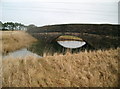
Bridge Over Pond
This bridge just seems to cross a very small pond but the pond is all that remains of a railway cutting. Move more than 10m away from the bridge and you couldn't tell there was once a railway cutting
Image: © Iain Thompson
Taken: 24 Nov 2006
0.06 miles
2
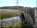
Stranded Railway Bridge
Well preserved stone arch bridge carries the unclassified road from Bonnington Linn to Douglas Water over the flooded cutting of the old Caledonian Railway line from Lanark to Poniel Junction. The adjacent landscape has ploughed and cultivated the line of the railway into total oblivion, with only this fossil trace of our railway heritage hereabouts.
The resultant pond is a biologist's and swimmer's dream location.
Image: © Keith Burns
Taken: 16 Mar 2011
0.06 miles
3
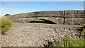
Easter Tofts Railway Bridge
This bridge takes cars over the former railway between Lanark and Peniel Junction on a minor road SW of Douglas Water. It used to flood a lot around the bridge due to disused coal mine workings. So now extra stone fills the void. There is a rivet and cut bench mark on the western tower of the bridge.
Image: © Rude Health
Taken: 29 Sep 2013
0.08 miles
4
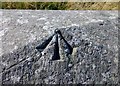
Rivet Bench Mark Easter Tofts Railway Bridge
This bridge takes cars over the former railway between Lanark and Peniel Junction on a minor road SW of Douglas Water.
Image: © Rude Health
Taken: 29 Sep 2013
0.09 miles
5

Road Bridge over the former Lanark to Poniel Junction Railway
2 other photographs of this bridge show the ground flooded under the bridge. Clearly this was not the case on the day of my visit.
Image: © G Laird
Taken: 4 Sep 2013
0.09 miles
6
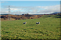
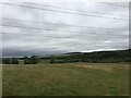
Grazing Land In The Douglas Water Valley
Grazing land on the west side of Douglas Water. The disused colliery spoil heap at Rigside is in the next square.
Image: © Mary and Angus Hogg
Taken: 10 Nov 2016
0.10 miles
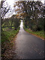
7

Hedge-lined minor road approaching Easter Tofts
Looking north-eastward.
Image: © Peter Wood
Taken: 1 Jun 2019
0.11 miles
8
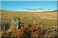
After The Harvest
Good arable land in the valley of the Douglas Water, viewed in mid-November.
Image: © Mary and Angus Hogg
Taken: 10 Nov 2016
0.12 miles
9
Minor Road
Minor road and cycle route near Douglas Water
Image: © Iain Thompson
Taken: 24 Nov 2006
0.13 miles