IMAGES TAKEN NEAR TO
Lesmahagow, LANARK, ML11 0JH
Introduction
This page details the photographs taken nearby to ML11 0JH by members of the Geograph project.
The Geograph project started in 2005 with the aim of publishing, organising and preserving representative images for every square kilometre of Great Britain, Ireland and the Isle of Man.

There are currently over 7.5m images from over14,400 individuals and you can help contribute to the project by visiting https://www.geograph.org.uk
Image Map
Images are licensed for reuse under creativecommons.org/licenses/by-sa/2.0
Notes
- Clicking on the map will re-center to the selected point.
- The higher the marker number, the further away the image location is from the centre of the postcode.
Image Listing (5 Images Found)
Images are licensed for reuse under creativecommons.org/licenses/by-sa/2.0
Image
Details
Distance
2
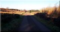
New service road for the Auchrobert Wind Farm
The public road is unsuitable for very long vehicles, so this stretch of track was specially constructed to aid access for the erection of the turbine towers.
Image: © Gordon Brown
Taken: 28 Nov 2020
0.06 miles
3
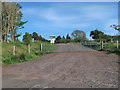
Entrance to Auchrobert Wind Farm
A recent 36MW construction in which the Auchrobert Community Energy Society have a stake. Its aim is to provide social and environmental benefits to people local to the wind farm. More details can be found at https://auchrobert.coop/
Image: © wrobison
Taken: 27 May 2020
0.07 miles
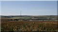
5
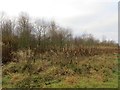
Woodland, Kypeside
Near a trout fishery.
Image: © Richard Webb
Taken: 23 Nov 2013
0.19 miles