IMAGES TAKEN NEAR TO
Byrd Crescent, MILTON KEYNES, MK7 8AF
Introduction
This page details the photographs taken nearby to Byrd Crescent, MK7 8AF by members of the Geograph project.
The Geograph project started in 2005 with the aim of publishing, organising and preserving representative images for every square kilometre of Great Britain, Ireland and the Isle of Man.

There are currently over 7.5m images from over14,400 individuals and you can help contribute to the project by visiting https://www.geograph.org.uk
Image Map
Images are licensed for reuse under creativecommons.org/licenses/by-sa/2.0
Notes
- Clicking on the map will re-center to the selected point.
- The higher the marker number, the further away the image location is from the centre of the postcode.
Image Listing (16 Images Found)
Images are licensed for reuse under creativecommons.org/licenses/by-sa/2.0
Image
Details
Distance
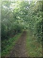
4
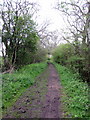
Bridleway to Wavendon across the fields
Image: © Philip Jeffrey
Taken: 6 May 2012
0.17 miles
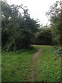
5
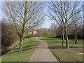
Footpath towards the Wavendon bridlepath
Running parallel with the small stream the path runs between Rackstraw Grove and Handel Mead.
Image: © Shirley Jones
Taken: 11 Mar 2010
0.18 miles
6
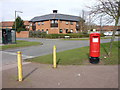
Britten Grove Postbox and bus shelter
Close to the junction with Arne Lane the Old Farm Park postbox is positioned where a footpath joins the road from the east.
Image: © Shirley Jones
Taken: 3 Mar 2010
0.19 miles
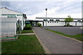
7
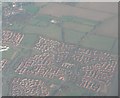
Milton Keynes: suburbs from the air
An overview of this square at the edge of the Milton Keynes sprawl.
In the very top-left of the picture you can see the church at Wavendon, which is top-right of the map in the next square northeast. Halfway down the left-hand edge of the picture is the large building just above centre of the gridsquare, which seems to be a school.
Going right from this building, you can see the distinction between 'fenced' and 'unfenced' roads on the map (dotted and solid lines respectively), after which the road proceeds downwards meeting the trunk road at the large roundabout towards the bottom-left of picture.
To the right, the housing development is visible with a clarity that individual roads can almost be discerned, albeit in a complex network, and the railway line can just be made out in the bottom-right corner, along the back gardens of the last houses in the estate.
Image: © Chris Downer
Taken: 12 Nov 2007
0.19 miles
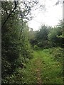
8
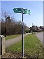
Finger post for horse owners
The bridle route for riders is indicated on Boyce Crescent
Image: © Shirley Jones
Taken: 11 Mar 2010
0.20 miles
9
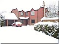
Goldmark Close, Old Farm Park
Typical 1990s dwelling in south east corner of 1960s new town Milton Keynes. This is a Tay Home (company now defunct) and one of 18 detached houses built on a plot on former farm land. All streets locally are named after composers. Goldmark was Hungarian.
Image: © Shirley Jones
Taken: 18 Dec 2009
0.20 miles