IMAGES TAKEN NEAR TO
Davy Avenue, MILTON KEYNES, MK5 8PL
Introduction
This page details the photographs taken nearby to Davy Avenue, MK5 8PL by members of the Geograph project.
The Geograph project started in 2005 with the aim of publishing, organising and preserving representative images for every square kilometre of Great Britain, Ireland and the Isle of Man.

There are currently over 7.5m images from over14,400 individuals and you can help contribute to the project by visiting https://www.geograph.org.uk
Image Map
Images are licensed for reuse under creativecommons.org/licenses/by-sa/2.0
Notes
- Clicking on the map will re-center to the selected point.
- The higher the marker number, the further away the image location is from the centre of the postcode.
Image Listing (23 Images Found)
Images are licensed for reuse under creativecommons.org/licenses/by-sa/2.0
Image
Details
Distance
1
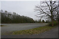
Is this an old car park?
Our walk has taken us close to the National Bowl and what might have been one of the car parks.
Image: © Malcolm Neal
Taken: 27 Mar 2022
0.09 miles
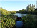
2
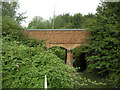
Foot Bridge crossing Tear Drop Lakes
A side view of one of the foot bridges in Loughton Valley Park, more common knows as Tear Drop Lakes. This is the most south westerly one of the foot bridges, located in SP8436.
Image: © Mr Biz
Taken: 27 Jul 2006
0.11 miles
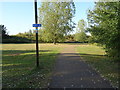
3
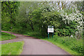
Path to the Teardrop Lakes
Part of Milton Keynes' vast network of surfaced paths, this leads down to the four interconnected Teardrop Lakes. The sign gives passers-by some details of what to expect.
Image: © Stephen McKay
Taken: 10 May 2023
0.13 miles
4
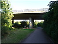
Chaffron Way bridge over National Cycle Route 51
Image: © JThomas
Taken: 21 Sep 2019
0.14 miles
5
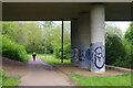
Under Chaffron Way
A woman heads along the path leading towards the four interconnected Teardrop Lakes although she might turn left back towards Chaffron Way.
Image: © Stephen McKay
Taken: 10 May 2023
0.14 miles
6
National Cycle Route 51, South Loughton Valley Park
Image: © JThomas
Taken: 21 Sep 2019
0.14 miles
7
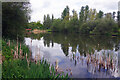
The Teardrop Lakes, Milton Keynes
This is one of four Teardrop Lakes, named for their shape. They act as balancing ponds, preventing flooding of the surrounding urban area following storms, but are also an important part of Milton Keynes' network of parks.
Image: © Stephen McKay
Taken: 10 May 2023
0.15 miles
9
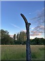
National Cycle Network milepost on route 51
Image: © Philip Jeffrey
Taken: 2 Jul 2017
0.17 miles
10
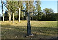
Millennium milepost, National Cycle Route 51, Knowlhill, Milton Keynes
Image: © JThomas
Taken: 21 Sep 2019
0.18 miles