IMAGES TAKEN NEAR TO
Luton Road, BEDFORD, MK45 4LG
Introduction
This page details the photographs taken nearby to Luton Road, MK45 4LG by members of the Geograph project.
The Geograph project started in 2005 with the aim of publishing, organising and preserving representative images for every square kilometre of Great Britain, Ireland and the Isle of Man.

There are currently over 7.5m images from over14,400 individuals and you can help contribute to the project by visiting https://www.geograph.org.uk
Image Map
Images are licensed for reuse under creativecommons.org/licenses/by-sa/2.0
Notes
- Clicking on the map will re-center to the selected point.
- The higher the marker number, the further away the image location is from the centre of the postcode.
Image Listing (4 Images Found)
Images are licensed for reuse under creativecommons.org/licenses/by-sa/2.0
Image
Details
Distance
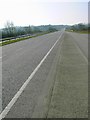
1
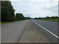
The A6 Looking Towards Luton
The Local Population Know this Road as the Barton Cutting
Image: © Raymond Cubberley
Taken: 21 Jul 2012
0.16 miles
2
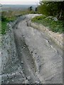
Devils Pit 4 X 4 track
At the top of the 4 X 4 course.
Image: © John Yaxley
Taken: 11 Apr 2007
0.21 miles
4
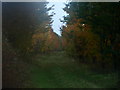
Permissive Path
runs parallel with the slip road from the A6 into Barton le Clay
Image: © Dennis simpson
Taken: 31 Oct 2010
0.24 miles