IMAGES TAKEN NEAR TO
Summerhouse Hill, BEDFORD, MK44 3SD
Introduction
This page details the photographs taken nearby to Summerhouse Hill, MK44 3SD by members of the Geograph project.
The Geograph project started in 2005 with the aim of publishing, organising and preserving representative images for every square kilometre of Great Britain, Ireland and the Isle of Man.

There are currently over 7.5m images from over14,400 individuals and you can help contribute to the project by visiting https://www.geograph.org.uk
Image Map
Images are licensed for reuse under creativecommons.org/licenses/by-sa/2.0
Notes
- Clicking on the map will re-center to the selected point.
- The higher the marker number, the further away the image location is from the centre of the postcode.
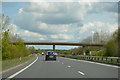
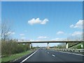
Image Listing (5 Images Found)
Images are licensed for reuse under creativecommons.org/licenses/by-sa/2.0
Image
Details
Distance
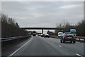
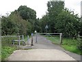
2
Bedford bypass / Meadow Lane
The sweet lane name doesn't quite fit with its current route, to the left is the sewage works, to the right is the abattoir.
Image: © Mr Ignavy
Taken: 28 Oct 2011
0.19 miles
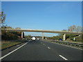
5
The Ouse Valley Way
Here heading towards Willington from Bedford and the Priory Country Park, along the track of an old railway.
Image: © M J Richardson
Taken: 8 Sep 2008
0.24 miles