IMAGES TAKEN NEAR TO
Thurleigh Airfield Business Park, BEDFORD, MK44 2YP
Introduction
This page details the photographs taken nearby to Thurleigh Airfield Business Park, MK44 2YP by members of the Geograph project.
The Geograph project started in 2005 with the aim of publishing, organising and preserving representative images for every square kilometre of Great Britain, Ireland and the Isle of Man.

There are currently over 7.5m images from over14,400 individuals and you can help contribute to the project by visiting https://www.geograph.org.uk
Image Map
Images are licensed for reuse under creativecommons.org/licenses/by-sa/2.0
Notes
- Clicking on the map will re-center to the selected point.
- The higher the marker number, the further away the image location is from the centre of the postcode.
Image Listing (7 Images Found)
Images are licensed for reuse under creativecommons.org/licenses/by-sa/2.0
Image
Details
Distance
1
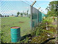
Bedford Autodrome perimeter 2
Here the bridleway crosses some old concrete from RAF days near Whitwickgreen Farm.
Image: © Jonathan Billinger
Taken: 27 Jul 2009
0.06 miles
2
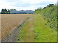
Whitwickgreen Farm
Looking west from the bridleway junction at Image
Image: © Jonathan Billinger
Taken: 27 Jul 2009
0.14 miles
3
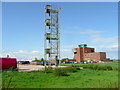
Ex-military infrastructure 1
Control tower of what was Thurleigh Airfield.
Image: © Jonathan Billinger
Taken: 27 Jul 2009
0.18 miles
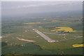
4
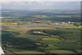
Bedford (Thurleigh) aerodrome, disused: aerial
From the NW.
Now used mostly for storing cars.
Radar installation in the foreground.
Image: © Chris
Taken: 13 Jun 2013
0.22 miles
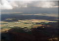
5
Bedford (Thurleigh) aerodrome, disused: aerial
Now used mostly for storing cars.
View from the west.
Image: © Chris
Taken: 16 Jun 2013
0.22 miles
6
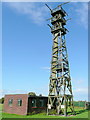
Ex-military infrastructure 2
Look-out tower in the south-east corner of the old Thurleigh Airfield.
Image: © Jonathan Billinger
Taken: 27 Jul 2009
0.23 miles
7
RAE Bedford
Originally opened as RAF Thurleigh, this airfield became the testing ground of the Royal Aircraft Establishment and was still in use when this photo was taken. The main runway was extended to its present length to accommodate the Bristol Brabazon airliner, which needed a lot of runway to get airborne. The RAE consolidated its resources at Boscombe down and the airfield closed in 1994. Once proposed as another airport for London, it is now a business park and new vehicle store.
Image: © Martin Addison
Taken: 11 Oct 1989
0.25 miles