IMAGES TAKEN NEAR TO
High Street, BEDFORD, MK43 0QR
Introduction
This page details the photographs taken nearby to High Street, MK43 0QR by members of the Geograph project.
The Geograph project started in 2005 with the aim of publishing, organising and preserving representative images for every square kilometre of Great Britain, Ireland and the Isle of Man.

There are currently over 7.5m images from over14,400 individuals and you can help contribute to the project by visiting https://www.geograph.org.uk
Image Map
Images are licensed for reuse under creativecommons.org/licenses/by-sa/2.0
Notes
- Clicking on the map will re-center to the selected point.
- The higher the marker number, the further away the image location is from the centre of the postcode.
Image Listing (19 Images Found)
Images are licensed for reuse under creativecommons.org/licenses/by-sa/2.0
Image
Details
Distance
1
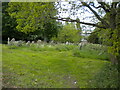
Graveyard south east of Lidlington
Once the churchyard of All Saints' Church, of which little remains.
Image: © Richard Vince
Taken: 7 May 2022
0.15 miles
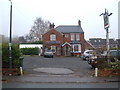
3
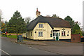
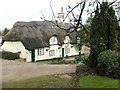
The Green Man
17th century grade II listed pub at the top end of Lidlington village. For around three years from 2001 it housed the village post office, the first pub in Bedfordshire to play this role.
For listing particulars see www.historicengland.org.uk/listing/the-list/list-entry/1321645.
Image: © Ian Capper
Taken: 6 Nov 2009
0.15 miles
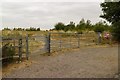
4
Boughton End Lane approaching Bury Ware
Image: © Mark Anderson
Taken: 22 Jul 2018
0.17 miles
5
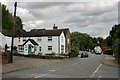
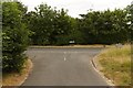
High Street, Lidlington
Taken at the junction of Church Street (right) and Church Lane (left).
Image: © David Kemp
Taken: 5 Sep 2009
0.17 miles
6
Folly Wood
Viewed from Boughton End Lane.
Image: © Mark Anderson
Taken: 22 Jul 2018
0.18 miles
7
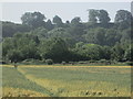
Wheat field, Lidlington
Part of the Marston Vale Timberland Trail between Lidlington and Stewartby. Jackdaw Hill is seen in the background.
Image: © Peter S
Taken: 29 Jun 2019
0.20 miles
8
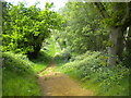
Public bridleway south east of Lidlington (2)
Forming part of the Marston Vale Trail. This was quite an ascent on what was turning out to be a surprisingly warm day, and I would imagine it would be tricky in either direction on horseback.
Image: © Richard Vince
Taken: 7 May 2022
0.20 miles
10
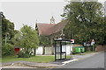
St Margaret, Lidlington
Surrounded by a bus shelter, garages and a pair of wheelie bins, the north-western aspect of the church is not its most scenic. The church was built in 1886 and replaced another, now demolished church in the gridsquare.
Image: © David Kemp
Taken: 5 Sep 2009
0.22 miles