IMAGES TAKEN NEAR TO
Tinkers Road, BEDFORD, MK42 0ZT
Introduction
This page details the photographs taken nearby to Tinkers Road, MK42 0ZT by members of the Geograph project.
The Geograph project started in 2005 with the aim of publishing, organising and preserving representative images for every square kilometre of Great Britain, Ireland and the Isle of Man.

There are currently over 7.5m images from over14,400 individuals and you can help contribute to the project by visiting https://www.geograph.org.uk
Image Map
Images are licensed for reuse under creativecommons.org/licenses/by-sa/2.0
Notes
- Clicking on the map will re-center to the selected point.
- The higher the marker number, the further away the image location is from the centre of the postcode.
Image Listing (15 Images Found)
Images are licensed for reuse under creativecommons.org/licenses/by-sa/2.0
Image
Details
Distance
1
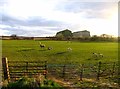
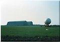
Fields west of Southill Road
The hangars built for the R100 and R101 airships are in the distance.
Image: © Andrew Tatlow
Taken: 5 Apr 2010
0.08 miles
2
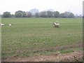
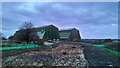
Sheep and Sheds
Grazing sheep in a field by Southill Road, with the Cardington Airship Sheds visible through the rain beyond.
Image: © M J Richardson
Taken: 25 Apr 2010
0.10 miles
4
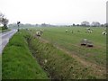
Sheep alongside Southill Road
A rainy day near Cardington.
Image: © M J Richardson
Taken: 25 Apr 2010
0.20 miles
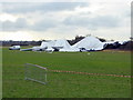
5
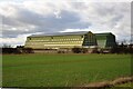
Airship hangars
The old airship hangars at Cardington. Known as the Royal Airship Works, it built airships for the Admiralty between 1919 and 1930, until the crash of airship R101 stopped all airship work. It later built barrage balloons for the WW2 effort.
Image: © Bob Walters
Taken: 17 Feb 2023
0.20 miles
6
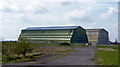
Cardington airship hangars with tethered airship
Image: © Philip Jeffrey
Taken: 9 May 1994
0.21 miles
7
Cardington Airship Hangars
Viewed from the east. See Image for excellent description and links.
The nearer shed is No.2 shed. From 1970 onwards it was leased by the Fire Research Station (based in Borehamwood, Herts) as a large scale test facility, where fires could be lit in relatively still-air conditions. It eventually became part of the Building Research Establishment, which became BRE Ltd. in 1997, when privatised out of the civil service. No.2 hangar is in much better condition than No. 1, as it was completely reclad in the late 1980s.
Description augmented by another member.
Image: © Jonathan Billinger
Taken: 15 Apr 2008
0.21 miles
8
Cardington Airfield Airship Sheds
These sheds are 55m high and about 247m long by 83m across.
Image: © PAUL FARMER
Taken: 8 Nov 2015
0.21 miles
9
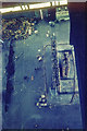
Cardington Airship Hangar No. 2 - Interior photo of E end in 1970
Part of the east end of Hangar No. 2 photographed in 1970. We are looking down from the central roof catwalk 163 feet above the floor of the hangar at an experimental high-rack storage system being subjected to fire tests by the Fire Research Station. (See Image for a more general view of the interior.)
Image: © John Webb
Taken: Unknown
0.22 miles
10
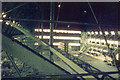
Airship Hangar No. 2 - Interior in 1970
A view from the central staircase on the north side of the hangar looking towards the east end from about 70 feet above floor level. This view was taken shortly after the Fire Research Station (then based at Borehamwood, Herts) leased part of the hangar from the Ministry of Defence for tests on high-rack storage. The racking in the middle distance of the photograph is about 40 feet high, to give some idea of the scale of this building.
For a more recent view see Image
Image: © John Webb
Taken: Unknown
0.23 miles