IMAGES TAKEN NEAR TO
Church Arcade, BEDFORD, MK40 1LQ
Introduction
This page details the photographs taken nearby to Church Arcade, MK40 1LQ by members of the Geograph project.
The Geograph project started in 2005 with the aim of publishing, organising and preserving representative images for every square kilometre of Great Britain, Ireland and the Isle of Man.

There are currently over 7.5m images from over14,400 individuals and you can help contribute to the project by visiting https://www.geograph.org.uk
Image Map
Images are licensed for reuse under creativecommons.org/licenses/by-sa/2.0
Notes
- Clicking on the map will re-center to the selected point.
- The higher the marker number, the further away the image location is from the centre of the postcode.
Image Listing (436 Images Found)
Images are licensed for reuse under creativecommons.org/licenses/by-sa/2.0
Image
Details
Distance
1
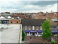
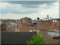
Bedford roofscape, Allhallows (3)
From the top of the Allhallows car park, we can see the tops of buildings on each side of Allhallows, and the junction with Greenhill Street. Beyond are the backs of buildings on Harpur Street which runs parallel to Allhallows.
For a view to the left of this one see Image]
For a view to the right of this one see Image]
Image: © Rich Tea
Taken: 19 Jun 2009
0.02 miles
3
Bedford roofscape, Allhallows (4)
From the top of the Allhallows car park, we can see the tops of buildings on each side of Allhallows. The small semicircular window left of centre is above The Arcade (from Harpur Street to High Street). The tallest building to the right is Debenhams at the corner of High Street and Silver Street.
For a view to the left of this one see Image]
For a view to the right of this one see Image]
Image: © Rich Tea
Taken: 19 Jun 2009
0.02 miles
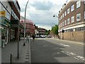
4
Harpur Street, Bedford
Standing near the junction with St Loyes Street, looking towards the junction with Midland Road and Silver Street.
Image: © Rich Tea
Taken: 19 Jun 2009
0.02 miles
5
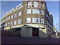
St Loyes Street, Bedford
With the BT offices on the right (known as Telephone House when my father worked there in the 1950's and 60's).
See the Harpur Street side of the building Image
During the 1960's the newer part of the building was being constructed with a tower crane. The crane was being extended or altered, when it collapsed onto the roof at the top of the picture, just above the room where my father worked. Fortunately it was Sunday, so the offices were empty. The road was closed for a few days while they cleared up the mess.
Image: © Rich Tea
Taken: 19 Jun 2009
0.03 miles
6
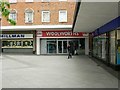
Woolworths, Church Square, Bedford
The rear entrance of the store which closed some months ago, and is still unused.
See also Image]
Image: © Rich Tea
Taken: 19 Jun 2009
0.03 miles
7
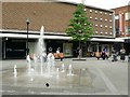
Church Square, Bedford
The Church in the name was probably Allhallows, a church which no longer exists.
The building across the square was built in the early 1960's and originally housed a supermarket called Fine Fare, which I think was the first supermarket in Bedford, preceding Sainsbury's (who at that time had a small shop on Midland Road, now part of Marks & Spencer's).
Image: © Rich Tea
Taken: 19 Jun 2009
0.04 miles
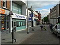
8
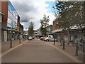
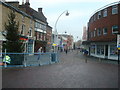
Dame Jane's Street, Bedford
Pedestrianised shopping precinct in Bedford town centre http://www.bedford.gov.uk/business/retail_and_business_in_bedford/shopping_centres.aspx
Image: © Paul Gillett
Taken: 16 May 2012
0.04 miles