IMAGES TAKEN NEAR TO
Bourton, BUCKINGHAM, MK18 7DX
Introduction
This page details the photographs taken nearby to MK18 7DX by members of the Geograph project.
The Geograph project started in 2005 with the aim of publishing, organising and preserving representative images for every square kilometre of Great Britain, Ireland and the Isle of Man.

There are currently over 7.5m images from over14,400 individuals and you can help contribute to the project by visiting https://www.geograph.org.uk
Image Map
Images are licensed for reuse under creativecommons.org/licenses/by-sa/2.0
Notes
- Clicking on the map will re-center to the selected point.
- The higher the marker number, the further away the image location is from the centre of the postcode.
Image Listing (37 Images Found)
Images are licensed for reuse under creativecommons.org/licenses/by-sa/2.0
Image
Details
Distance
1
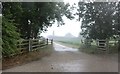
Track to Bourton Grounds, Thornborough
This has been left exactly as it was taken, the haze over the farm was due to the heavy rain being broken up by the reflected sunlight on the other side of the sky. There were no major rainbows till around an hour later with a less severe shower.
Image: © David Howard
Taken: 13 Jun 2020
0.02 miles
3
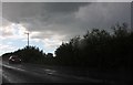
Heavy downpour on the A421, Thornborough
I have done no editing to this to show the light exactly as it was at the time.
Image: © David Howard
Taken: 13 Jun 2020
0.05 miles
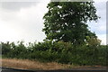
4
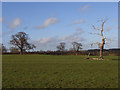
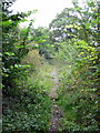
Pastures, Bourton Grounds
On the footpath between Thornborough Bridge and White House Farm.
Image: © Andrew Smith
Taken: 11 Feb 2007
0.07 miles
5
The old A421 west of Thornborough Bridge
Image: © Philip Jeffrey
Taken: 2 Oct 2012
0.17 miles
7
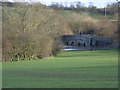
Thornborough Bridge
Looking down from the hillside below White House Farm.
Image: © Andrew Smith
Taken: 11 Feb 2007
0.19 miles
8
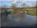
Padbury Brook in flood
Looking downstream from Thornborough Bridge.
Image: © Andrew Smith
Taken: 11 Feb 2007
0.19 miles
9
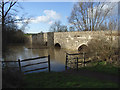
Thornborough Bridge
Buckinghamshire's oldest surviving bridge. It was replaced by a new one in 1974 and dates back to 1400.
Image: © Andrew Smith
Taken: 11 Feb 2007
0.19 miles
10
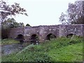
Thornborough Bridge looking North
The medieval bridge (c1400) over the Claydon Brook (a tributary of the Great Ouse) at Thornborough, north Bucks. It is the only extant medieval bridge in Bucks and once formed part of the A421. The road was diverted many years ago to protect this Ancient Monument.
Image: © mick finn
Taken: 4 Oct 2008
0.19 miles