IMAGES TAKEN NEAR TO
Hillesden, BUCKINGHAM, MK18 4DT
Introduction
This page details the photographs taken nearby to MK18 4DT by members of the Geograph project.
The Geograph project started in 2005 with the aim of publishing, organising and preserving representative images for every square kilometre of Great Britain, Ireland and the Isle of Man.

There are currently over 7.5m images from over14,400 individuals and you can help contribute to the project by visiting https://www.geograph.org.uk
Image Map
Images are licensed for reuse under creativecommons.org/licenses/by-sa/2.0
Notes
- Clicking on the map will re-center to the selected point.
- The higher the marker number, the further away the image location is from the centre of the postcode.
Image Listing (9 Images Found)
Images are licensed for reuse under creativecommons.org/licenses/by-sa/2.0
Image
Details
Distance
1
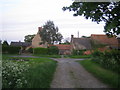
Westfield Farm near Hillesden
Westfield Farm lies a third of the way down a no-through-road that runs east off the C road between Buckingham in the north and Edgcott in the south. Off camera, the road then skirts round the farm buildings to the right and continues east down to Manor Farm, from where a footpath goes to Hillesden. There is a photo in the English Heritage records from sometime in the period 1896 to 1920 of a lady standing at the gateway of the farmhouse with her chickens http://viewfinder.english-heritage.org.uk/search/reference.asp?index=985&imageUID=84931&main_query=&theme=&period=&county=&district=&place_name=Ham
Image: © Andy Gryce
Taken: 19 May 2007
0.01 miles
2
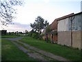
Westfield Farm near Hillesden
This is an alternative view of Westfield Farm looking north, see Image, from the no-through-road to Manor Farm, that runs east off the Buckingham to Edgcott C road.
Image: © Andy Gryce
Taken: 19 May 2007
0.03 miles


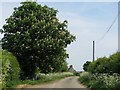
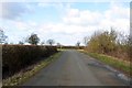
7
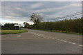
Junction on the road to Gawcott
Most of the roads here appear to have no names.
Image: © David Howard
Taken: 11 Oct 2020
0.19 miles