IMAGES TAKEN NEAR TO
Cherry Leys, BUCKINGHAM, MK18 2RL
Introduction
This page details the photographs taken nearby to Cherry Leys, MK18 2RL by members of the Geograph project.
The Geograph project started in 2005 with the aim of publishing, organising and preserving representative images for every square kilometre of Great Britain, Ireland and the Isle of Man.

There are currently over 7.5m images from over14,400 individuals and you can help contribute to the project by visiting https://www.geograph.org.uk
Image Map
Images are licensed for reuse under creativecommons.org/licenses/by-sa/2.0
Notes
- Clicking on the map will re-center to the selected point.
- The higher the marker number, the further away the image location is from the centre of the postcode.
Image Listing (29 Images Found)
Images are licensed for reuse under creativecommons.org/licenses/by-sa/2.0
Image
Details
Distance
1
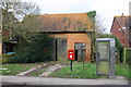
Outbuilding to right of #9 Buckingham Road
There is an OS benchmark Image on the front of the building at its left hand corner where the wooden fence abuts
Image: © Roger Templeman
Taken: 2 Mar 2017
0.08 miles
2
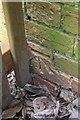
Benchmark on outbuilding next to #9 Buckingham Road
Ordnance Survey cut mark benchmark described on the Bench Mark Database at http://www.bench-marks.org.uk/bm82540
Image: © Roger Templeman
Taken: 2 Mar 2017
0.08 miles
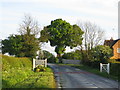
6
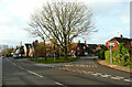
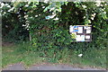
Road junction in Steeple Claydon
Here there is a little green with a seat and trees.
Image: © Humphrey Bolton
Taken: 30 Jan 2022
0.13 miles
8
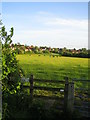
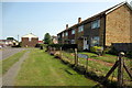
Field and edge of village, Steeple Claydon
This view to the south shows part of the northern edge of Steeple Claydon across a field. The village is in north-west Buckinghamshire, and has a population of about 1,600, and is one of four villages, the others being East Claydon, Middle Claydon, and Botolph Claydon, known collectively as The Claydons. All the houses in this photograph are relatively new, the older part of the village being a little further south.
Image: © Andy Gryce
Taken: 12 May 2007
0.14 miles
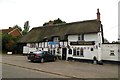
9
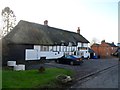
The Phoenix pub, Steeple Claydon
A C17/C18 building. See http://www.britishlistedbuildings.co.uk/en-399975-the-phoenix-steeple-claydon-buckinghamsh for entry in British Listed Buildings
Image: © Bikeboy
Taken: 2 Jan 2015
0.14 miles
10
Village boundary, Steeple Claydon
This is the north-east edge of the village of Steeple Claydon on the Buckingham Road that comes from Padbury 4km to the north-west. Steeple Claydon is one of four villages in north Buckinghamshire collectively known as The Claydons. The name comes from the Old English clægig + dun and means 'clayey hill', and much of Steeple Claydon lies on a hill which is over 100m. The village church, St Michael's, is near the top of the hill and its spire dominates the skyline, and hence 'Steeple' was used to distinguish the village from the other Claydons.
Image: © Andy Gryce
Taken: 12 May 2007
0.14 miles