IMAGES TAKEN NEAR TO
Church Way, BUCKINGHAM, MK18 2ND
Introduction
This page details the photographs taken nearby to Church Way, MK18 2ND by members of the Geograph project.
The Geograph project started in 2005 with the aim of publishing, organising and preserving representative images for every square kilometre of Great Britain, Ireland and the Isle of Man.

There are currently over 7.5m images from over14,400 individuals and you can help contribute to the project by visiting https://www.geograph.org.uk
Image Map
Images are licensed for reuse under creativecommons.org/licenses/by-sa/2.0
Notes
- Clicking on the map will re-center to the selected point.
- The higher the marker number, the further away the image location is from the centre of the postcode.
Image Listing (31 Images Found)
Images are licensed for reuse under creativecommons.org/licenses/by-sa/2.0
Image
Details
Distance
2
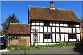
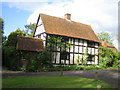
Beech House, East Claydon
The older, timbered part is 17th century. Grade II listed. Viewed from the churchyard.
Image: © Robin Webster
Taken: 27 Mar 2015
0.00 miles
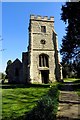
3
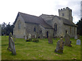
St Mary the Virgin Church, East Claydon
This is the parish church of East Claydon which is on top of Sion Hill on the eastern edge of the village at a height of 120m. The earliest part of the church at the beginning of the 13th century was an aisle-less nave and chancel, and the first rector was recorded as Richard Hanley in 1218. The tower was added in the late 15th or early 16th century. The church is said to have been damaged by Cromwell's men in the Civil War, and was only completely restored by Sir Gilbert Scott in 1871. In 1976 the parishes of East, Middle and Steeple Claydon were united, each with its own parish church, to become the Parish of the Claydons. The name Claydon derives from the old english clægig + dun and means 'clayey hill', and Claindone is the name given for Claydon in the Domesday Book in 1086.
Image: © Andy Gryce
Taken: 22 Apr 2007
0.02 miles
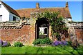
4
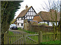
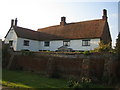
Beech House, Church Way, East Claydon
This Elizabethan house is on a small triangular green at the end of Church Way on the eastern edge of the village of East Claydon. The gate to the parish church, St Mary the Virgin, is just off camera to the right, see Image
Image: © Andy Gryce
Taken: 12 May 2007
0.02 miles
5
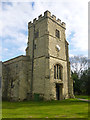
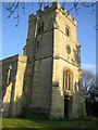
Tower, East Claydon church
St. Mary's is a grade II*(star) listed building.
Image: © Robin Webster
Taken: 27 Mar 2015
0.02 miles
7
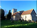
St Mary's East Claydon
The chancel is C14 and the tower C15-C16. The church was badly damaged/demolished during the Civil War and rebuilt after the restoration of the monarchy. The church was extensively restored by George Gilbert Scott in 1871
Image: © Bikeboy
Taken: 2 Jan 2015
0.03 miles
9
Whitehouse Farm, East Claydon
Whitehouse Farm is named on the OS 1:25,000 map. Over the doorway, there is a stone inscription with interwoven letters and the date 1894, though the building, and the wall, is obviously much older.
Image: © Andy Gryce
Taken: 22 Apr 2007
0.03 miles
10
East Claydon church
St. Mary's is a grade II*(star) listed building.
Image: © Robin Webster
Taken: 27 Mar 2015
0.03 miles