IMAGES TAKEN NEAR TO
Brooks Court, BUCKINGHAM, MK18 1DG
Introduction
This page details the photographs taken nearby to Brooks Court, MK18 1DG by members of the Geograph project.
The Geograph project started in 2005 with the aim of publishing, organising and preserving representative images for every square kilometre of Great Britain, Ireland and the Isle of Man.

There are currently over 7.5m images from over14,400 individuals and you can help contribute to the project by visiting https://www.geograph.org.uk
Image Map
Images are licensed for reuse under creativecommons.org/licenses/by-sa/2.0
Notes
- Clicking on the map will re-center to the selected point.
- The higher the marker number, the further away the image location is from the centre of the postcode.
Image Listing (160 Images Found)
Images are licensed for reuse under creativecommons.org/licenses/by-sa/2.0
Image
Details
Distance
2
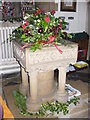
Buckingham Font
Christmas decorations on the font within the Church of Saints Peter and Paul.
http://www.buckingham-tc.gov.uk/
Image: © Colin Smith
Taken: 2 Jan 2010
0.04 miles
3
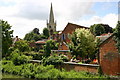
Buckingham Church
Looking across the Great Ouse near Ford Street to Buckingham Church
Image: © Shaun Ferguson
Taken: 7 Jul 2007
0.05 miles
4

Remember
Evocative kneeler within the Victorian Gothic Buckingham Church.
http://www.buckingham-tc.gov.uk/
Image: © Colin Smith
Taken: 2 Jan 2010
0.05 miles
5
Buckingham Ford
This ford on the River Great Ouse, in the centre of Buckingham, is found on Ford Lane. There is a high lip to the concrete wall on the near side.
Image: © John Walton
Taken: 16 Jun 2013
0.05 miles
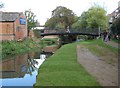
6
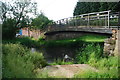
Buckingham: The Ford
Once upon a time this ford over the River Great Ouse was the main route into the centre of the town from the south, and the whole thoroughfare up to Well Street in the distance was known as Ford Street. By 1805 the main London Bridge had been built further downstream, to the east and to the right, and the ford lost its importance. Today the pedestrian Woolpack Bridge on the left has replaced an earlier structure, and the road on the far side has been renamed as an extension of Elm Street, coming down across and from the far side of Well Street. Nonetheless the tyre tracks in the mud indicate that some use of it is still made by motor traffic today.
The Buckingham Town Council Winter 2010 newsletter has some news on the ford here http://www.buckingham-tc.gov.uk/newsitems/newsletter_storage/2010-01-newsletter_web.pdf
Image: © Nigel Cox
Taken: 17 Oct 2010
0.05 miles
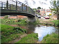
7
Buckingham: The Woolpack Bridge
The current bridge dates from 1988 and replaced an earlier six arch stone bridge over the River Great Ouse. Image is just beyond the bridge, while the outbuildings of The Woolpack public house are visible left.
The pedestrian route along the river is known as the Chris Nicholls Walk. Returfing and reseeding of the river bank has evidently recently taken place.
Image: © Nigel Cox
Taken: 17 Oct 2010
0.05 miles
8
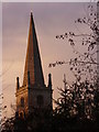
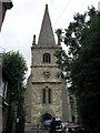
Buckingham Church Spire
The spire of Saints Peter and Paul seen against a cold evening sky.
http://www.buckingham-tc.gov.uk/
Image: © Colin Smith
Taken: 2 Jan 2010
0.06 miles
9
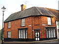
Red Brick Buckingham
Distinctive old house at the corner of Church and Well Streets.
http://www.buckingham-tc.gov.uk/
Image: © Colin Smith
Taken: 2 Jan 2010
0.06 miles
10
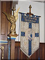
Church Banner, Buckingham
Within the Victorian Gothic Church of Saints Peter and Paul.
http://www.buckingham-tc.gov.uk/
Image: © Colin Smith
Taken: 2 Jan 2010
0.06 miles