IMAGES TAKEN NEAR TO
Watling Street, MILTON KEYNES, MK17 9HA
Introduction
This page details the photographs taken nearby to Watling Street, MK17 9HA by members of the Geograph project.
The Geograph project started in 2005 with the aim of publishing, organising and preserving representative images for every square kilometre of Great Britain, Ireland and the Isle of Man.

There are currently over 7.5m images from over14,400 individuals and you can help contribute to the project by visiting https://www.geograph.org.uk
Image Map
Images are licensed for reuse under creativecommons.org/licenses/by-sa/2.0
Notes
- Clicking on the map will re-center to the selected point.
- The higher the marker number, the further away the image location is from the centre of the postcode.
Image Listing (4 Images Found)
Images are licensed for reuse under creativecommons.org/licenses/by-sa/2.0
Image
Details
Distance
1
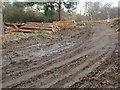
Logging activity on Rammamere Heath
Clearance work to rejuvenate heath land is ongoing.
Image: © Michael Trolove
Taken: 22 Jan 2012
0.10 miles
2
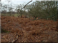
Rammamere Heath
View on the Greensand Ridge
Image: © Michael Trolove
Taken: 22 Jan 2012
0.18 miles
3
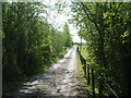
Driveway to Rammamere Farm
This driveway is also a bridleway according to my OS map, which joins up with the Greensand Ridge & Milton Keynes Boundary Walks.
Image: © Mr Biz
Taken: 12 May 2009
0.19 miles
4
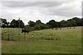
Grazing land east of Little Brickhill
Taken from near Rammamere Farm.
Image: © David Kemp
Taken: 29 Aug 2009
0.20 miles