IMAGES TAKEN NEAR TO
Deethe Close, MILTON KEYNES, MK17 8UP
Introduction
This page details the photographs taken nearby to Deethe Close, MK17 8UP by members of the Geograph project.
The Geograph project started in 2005 with the aim of publishing, organising and preserving representative images for every square kilometre of Great Britain, Ireland and the Isle of Man.

There are currently over 7.5m images from over14,400 individuals and you can help contribute to the project by visiting https://www.geograph.org.uk
Image Map
Images are licensed for reuse under creativecommons.org/licenses/by-sa/2.0
Notes
- Clicking on the map will re-center to the selected point.
- The higher the marker number, the further away the image location is from the centre of the postcode.
Image Listing (28 Images Found)
Images are licensed for reuse under creativecommons.org/licenses/by-sa/2.0
Image
Details
Distance
1
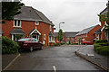
Turnpike
A new housing estate built with other housing estates in Woburn Sands.
Image: © Martin Addison
Taken: 27 May 2009
0.05 miles
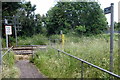
3

Ordnance Survey Cut Mark
This mark can be found on the wall of the Station Hotel.
For more detail see : http://www.bench-marks.org.uk/bm46484
Image: © Peter Wood
Taken: 29 Nov 2012
0.10 miles
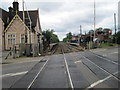
4
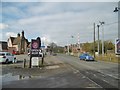
Woburn Sands, level crossing
Carrying the Bletchley to Bedford line across Station Road (A5130).
Image: © Mike Faherty
Taken: 17 Feb 2017
0.10 miles
5
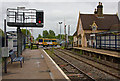
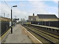
Woburn Sands Station
Looking towards Bedford. The station house on the left and the other station buildings are now available to let as business offices and meeting venues. Passengers are provided with bus shelters and steel seats.
One of the local MK buses can be seen crossing the railway on the A4012, heading towards Woburn. The route is currently supported by contractors Wimpey as part of their involvement in a local affordable housing scheme.
Image: © Martin Addison
Taken: 27 May 2009
0.10 miles
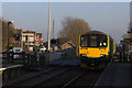
6
Woburn Sands, train
A Class 153 diesel unit waits on Platform 1 to leave for Bletchley.
Image: © Mike Faherty
Taken: 17 Feb 2017
0.10 miles
7
Woburn Sands railway station
Opened in 1846 by the London & North Western Railway on the Oxford to Cambridge line. View west towards Bow Brickhill and Bletchley.
Image: © Nigel Thompson
Taken: 9 Jun 2012
0.11 miles
8
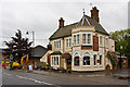
The Station Hotel, Woburn Sands
Understandably right next to the station, on the A4012 - called (you've guessed it) Station Road! I expect that the builder realised that the line was never going to be anything more than a branch, so the premises were kept to a modest scale.
Image: © Martin Addison
Taken: 27 May 2009
0.11 miles
9
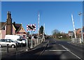
Woburn Sands station and level crossing
The Costa Coffee building on the left is the former Railway Station House. It was built in 1846. See http://www.britishlistedbuildings.co.uk/en-397745-railway-station-house-woburn-sands- for entry in British Listed Buildings
Image: © Bikeboy
Taken: 16 Feb 2014
0.11 miles
10
Woburn Sands station
The 13:24 London Midland train to Bletchley comes into Woburn Sands.
Image: © Robert Eva
Taken: 20 Dec 2016
0.11 miles