IMAGES TAKEN NEAR TO
High Street, MILTON KEYNES, MK17 8RF
Introduction
This page details the photographs taken nearby to High Street, MK17 8RF by members of the Geograph project.
The Geograph project started in 2005 with the aim of publishing, organising and preserving representative images for every square kilometre of Great Britain, Ireland and the Isle of Man.

There are currently over 7.5m images from over14,400 individuals and you can help contribute to the project by visiting https://www.geograph.org.uk
Image Map
Images are licensed for reuse under creativecommons.org/licenses/by-sa/2.0
Notes
- Clicking on the map will re-center to the selected point.
- The higher the marker number, the further away the image location is from the centre of the postcode.
Image Listing (30 Images Found)
Images are licensed for reuse under creativecommons.org/licenses/by-sa/2.0
Image
Details
Distance
3
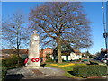
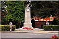
War memorial, Woburn Sands
In full, Woburn Sands and Aspley Heath War Memorial. It is grade II listed, and unusually incorporates a clock.
Image: © Robin Webster
Taken: 5 Dec 2021
0.04 miles
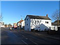
5
The Swan, Woburn Sands
See the sign "Buckinghamshire" below the pub sign at street level. This pub straddles the Beds/Bucks border.
Image: © Bikeboy
Taken: 16 Feb 2014
0.04 miles
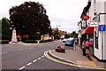
7
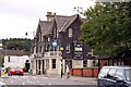
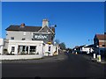
The Fir Tree Inn and High Street, Woburn Sands
Image: © Bikeboy
Taken: 16 Feb 2014
0.05 miles
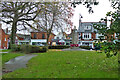
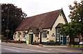
8
Woburn Sands, Institute
On High Street; the building is shared with the library. Preparations are underway for today's Christmas Fayre. http://www.woburnsands.org.uk/Woburn-Sands-Town-Council/woburn_sands_library-5433.aspx
Image: © Mike Faherty
Taken: 26 Nov 2017
0.05 miles
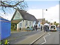
10
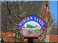
Woburn Sands village sign
As the sign says, it was formerly known as "Hogsty End". Before it became a town in its own right, it was one of the four ends of Wavenden (the others being Church End, Cross End and Lower End).
Image: © Bikeboy
Taken: 16 Feb 2014
0.06 miles