IMAGES TAKEN NEAR TO
Crabtree Lane, Lower End, MILTON KEYNES, MK17 8AP
Introduction
This page details the photographs taken nearby to Crabtree Lane, Lower End, MK17 8AP by members of the Geograph project.
The Geograph project started in 2005 with the aim of publishing, organising and preserving representative images for every square kilometre of Great Britain, Ireland and the Isle of Man.

There are currently over 7.5m images from over14,400 individuals and you can help contribute to the project by visiting https://www.geograph.org.uk
Image Map
Images are licensed for reuse under creativecommons.org/licenses/by-sa/2.0
Notes
- Clicking on the map will re-center to the selected point.
- The higher the marker number, the further away the image location is from the centre of the postcode.
Image Listing (15 Images Found)
Images are licensed for reuse under creativecommons.org/licenses/by-sa/2.0
Image
Details
Distance
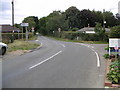
1
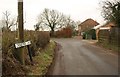
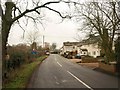
Crabtree Lane
The lane reaches a bend at Crabtree Farm. After another bend or two it becomes Salford Road.
Image: © Derek Harper
Taken: 5 Feb 2011
0.04 miles
2
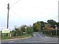
Crabtree Lane, near Woburn Sands
This image was taken on the border of Buckinghamshire and Bedfordshire. Crabtree Lane leads into Bedfordshire. Signs indicate that heavy lorries are prohibited from Crabtree Lane.
Image: © Malc McDonald
Taken: 20 Oct 2012
0.13 miles
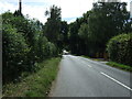
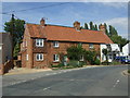
5
Cranfield Road
The road from Salford running through Lower End, and approaching the junction with Crabtree Lane.
Image: © Derek Harper
Taken: 5 Feb 2011
0.14 miles
7
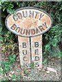
Old Boundary Marker
County Boundary Marker on the southwest side of the junction of Cranfield Road and Crow Lane. WAVENDON parish. Inscribed BUCKS | BEDS on its centre face and COUNTY / BOUNDARY at the top. See also http://pnelson.orpheusweb.co.uk/boundsbuck/boundsbuck1/gallery.htm
Milestone Society National ID: BU_WBCR00cb
Image: © D Markwell
Taken: 12 Jul 2019
0.14 miles
8
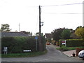
Crow Lane, near Woburn Sands
Crow Lane in the hamlet of Lower End, on the border of Buckinghamshire and Bedfordshire.
Image: © Malc McDonald
Taken: 20 Oct 2012
0.15 miles
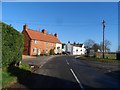
9
Dangerous Road Junction
A rather dangerous road junction that has resulted in the small brick wall to the right of the photo being destroyed several times as well as the owner's front room window!! This is the Crabtree Lane / Cranfield Road junction, with the Crow Lane dead end making this an almost crossroads on a bend.
Image: © Mr Biz
Taken: 11 Aug 2006
0.17 miles
10
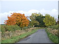
Autumn colours near Aspley Guise
The colour on the leaves on the tree to the left of the image show that the photograph was taken during the autumn.
Image: © Malc McDonald
Taken: 20 Oct 2012
0.17 miles