IMAGES TAKEN NEAR TO
Ostlers Lane, MILTON KEYNES, MK11 1AR
Introduction
This page details the photographs taken nearby to Ostlers Lane, MK11 1AR by members of the Geograph project.
The Geograph project started in 2005 with the aim of publishing, organising and preserving representative images for every square kilometre of Great Britain, Ireland and the Isle of Man.

There are currently over 7.5m images from over14,400 individuals and you can help contribute to the project by visiting https://www.geograph.org.uk
Image Map
Images are licensed for reuse under creativecommons.org/licenses/by-sa/2.0
Notes
- Clicking on the map will re-center to the selected point.
- The higher the marker number, the further away the image location is from the centre of the postcode.
Image Listing (89 Images Found)
Images are licensed for reuse under creativecommons.org/licenses/by-sa/2.0
Image
Details
Distance
1
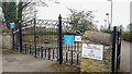
Entrance to Sports and Bowling Club, Stony Stratford
Attractive iron gate at the entrance to this Sports Club.
Image: © Christine Matthews
Taken: 19 Mar 2017
0.04 miles
2
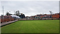
Bowling Green, Sports and Bowling Club, Stony Stratford
Image: © Christine Matthews
Taken: 19 Mar 2017
0.04 miles
3
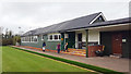
Sports and Bowling Club, Stony Stratford
Sports Club pavilion and bowling green.
Image: © Christine Matthews
Taken: 19 Mar 2017
0.04 miles
4
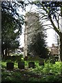
St Mary's Tower
Tower and graveyard of St Mary's Church - the tower was the only surviving building of the great fire which swept through the lower part of the town in 1742.
Image: © Malcolm Campbell
Taken: 8 Apr 2009
0.05 miles
5
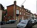
Tower House, 96 High Street, Stony Stratford
Formerly a solicitor's office on the A5.
Image: © Michael Flegg
Taken: 27 Jun 2008
0.05 miles
7
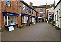
Fegan's Home
The building still occasionally referred to as Fegan's Home has had a number of uses in its lifetime, having been a school (St Paul's School), a cigar factory, a boys' home, a Franciscan school, a branch of an international finance company, and now an Indian Restaurant.
see http://www.mkheritage.co.uk/mkm/stonystratford/docs/tourframe.html
Image: © Malcolm Campbell
Taken: 8 Apr 2009
0.09 miles
8

High Street houses (Nos. 116, 114, 112)
The junction of the left hand house with the abutting arch is the probable site of an 1848 Ordnance Survey benchmark, described on the Bench Mark Database at http://www.bench-marks.org.uk/bm77193
Image: © Roger Templeman
Taken: 23 Nov 2016
0.09 miles
9
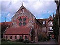
St. Mary Magdalene, Stony Stratford
Roman Catholic Church.
Image: © Cameraman
Taken: 3 Feb 2011
0.09 miles
10

'Rothenburg House', #107 High Street
There is an OS benchmark Image on the front of the building left of the hydrant sign
Image: © Roger Templeman
Taken: 23 Nov 2016
0.10 miles