IMAGES TAKEN NEAR TO
Lynsted Lane, SITTINGBOURNE, ME9 9RB
Introduction
This page details the photographs taken nearby to Lynsted Lane, ME9 9RB by members of the Geograph project.
The Geograph project started in 2005 with the aim of publishing, organising and preserving representative images for every square kilometre of Great Britain, Ireland and the Isle of Man.

There are currently over 7.5m images from over14,400 individuals and you can help contribute to the project by visiting https://www.geograph.org.uk
Image Map
Images are licensed for reuse under creativecommons.org/licenses/by-sa/2.0
Notes
- Clicking on the map will re-center to the selected point.
- The higher the marker number, the further away the image location is from the centre of the postcode.
Image Listing (10 Images Found)
Images are licensed for reuse under creativecommons.org/licenses/by-sa/2.0
Image
Details
Distance
1
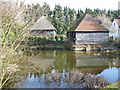
Pond at the side of Cellar Hill near junction with Lynsted Lane
Image: © pam fray
Taken: 3 Feb 2008
0.05 miles
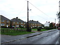
3
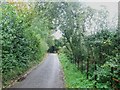
Hedge near the junction of Cellar Hill with Lynsted Lane
Lynsted Parish Council's Community hedge for the Millennium, with 14 native species. Planted by the children of Lynsted and Norton School and local residents.
Image: © pam fray
Taken: 3 Feb 2008
0.06 miles
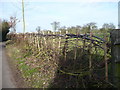
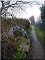
7
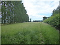
Footpath seen from Cambridge Lane
This short footpath goes around the back of Cambridge Farm to meet up with Cambridge Lane again on the way into Teynham.
Image: © Marathon
Taken: 21 Jun 2019
0.13 miles
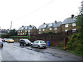
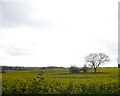
8
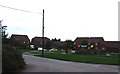
Cambridge Farm
Cambridge Farm is seen here from Cambridge Lane, to the south of Teynham.
Image: © Marathon
Taken: 21 Jun 2019
0.16 miles
10
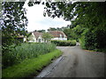
Footpath off Lynsted Lane
Leading to Mill Lane and Sunderland Farm.
Image: © pam fray
Taken: 16 Jan 2017
0.23 miles