IMAGES TAKEN NEAR TO
London Road, SITTINGBOURNE, ME9 9PT
Introduction
This page details the photographs taken nearby to London Road, ME9 9PT by members of the Geograph project.
The Geograph project started in 2005 with the aim of publishing, organising and preserving representative images for every square kilometre of Great Britain, Ireland and the Isle of Man.

There are currently over 7.5m images from over14,400 individuals and you can help contribute to the project by visiting https://www.geograph.org.uk
Image Map
Images are licensed for reuse under creativecommons.org/licenses/by-sa/2.0
Notes
- Clicking on the map will re-center to the selected point.
- The higher the marker number, the further away the image location is from the centre of the postcode.
Image Listing (37 Images Found)
Images are licensed for reuse under creativecommons.org/licenses/by-sa/2.0
Image
Details
Distance
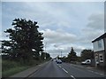
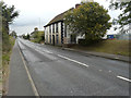
2
View towards the London Road from Claxfield farm buildings
Image: © pam fray
Taken: 3 Feb 2008
0.05 miles
3
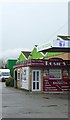
Rosie's Caf?, Teynham
On the London (A2) Road.
Image: © pam fray
Taken: 16 Jan 2017
0.05 miles
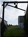
4
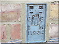
Ordnance Survey Flush Bracket 11934
This can be found on the wall of one of the converted cottages - a private dwelling - at Claxfield Farm.
For more detail see : http://www.bench-marks.org.uk/bm22064
Image: © Peter Wood
Taken: 18 Feb 2016
0.06 miles
5

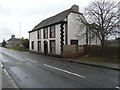
Claxfield House, London Road
It is a grade II listed building that was once a house but was converted into offices. It is timber framed and dates from the 17th century but was refaced (plastered) in the 18th century. It has a plain tiled roof
https://britishlistedbuildings.co.uk/101343927-claxfield-house-lynsted-with-kingsdown#.WA5Ahf4zXcc
This was Image before it was restored but it remains uninhabited.
Image: © John Baker
Taken: 2 Dec 2018
0.08 miles
6
Claxfield House, London Road
It is a grade II listed building that was once a house but was converted into offices. It is timber framed and dates from the 17th century but was refaced (plastered) in the 18th century. It has a plain tiled roof
https://britishlistedbuildings.co.uk/101343927-claxfield-house-lynsted-with-kingsdown#.WA5Ahf4zXcc
This was Image before it was restored but it remains uninhabited.
Image: © John Baker
Taken: 2 Dec 2018
0.08 miles
7
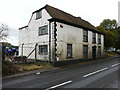
Claxfield House, London Road, Teynham, Kent, ME9 9PR
Planning permission has been granted by Swale Borough Council under application number SW/15/506224/LBC for “listed building consent for restoration and conservation of Claxfield House including demolition of small, single storey, modern flat roofed extension at rear”.
It is a grade II listed building that was once a house but was converted into offices. It is timber framed and dates from the 17th century but was refaced (plastered) in the 18th century. It has a plain tiled roof http://www.britishlistedbuildings.co.uk/en-176275-claxfield-house-lynsted-with-kingsdown-k#.WA5Ahf4zXcc
The planning application refers to the settlement as Teynham but the listed building entry refers to it as Lynsted with Kingsdown. Both have the same postcode.
Image: © John Baker
Taken: 9 Oct 2016
0.08 miles
8
Claxfield House, London Road, Teynham, Kent, ME9 9PR
Planning permission has been granted by Swale Borough Council under application number SW/15/506224/LBC for “listed building consent for restoration and conservation of Claxfield House including demolition of small, single storey, modern flat roofed extension at rear”.
It is a grade II listed building that was once a house but was converted into offices. It is timber framed and dates from the 17th century but was refaced (plastered) in the 18th century. It has a plain tiled roof http://www.britishlistedbuildings.co.uk/en-176275-claxfield-house-lynsted-with-kingsdown-k#.WA5Ahf4zXcc
The planning application refers to the settlement as Teynham but the listed building entry refers to it as Lynsted with Kingsdown. Both have the same postcode.
Image: © John Baker
Taken: 9 Oct 2016
0.09 miles
9

Claxfield Farmhouse, Claxfield Road, Teynham, Kent
Grade II* listed.
Image: © Oast House Archive
Taken: 19 Aug 2009
0.10 miles
10

Claxfield Farm
Claxfield Farm is seen here looking along Claxfield Road on the approach from the south. See also https://www.geograph.org.uk/photo/6190693
Image: © Marathon
Taken: 21 Jun 2019
0.10 miles