IMAGES TAKEN NEAR TO
Lower Road, SITTINGBOURNE, ME9 9BN
Introduction
This page details the photographs taken nearby to Lower Road, ME9 9BN by members of the Geograph project.
The Geograph project started in 2005 with the aim of publishing, organising and preserving representative images for every square kilometre of Great Britain, Ireland and the Isle of Man.

There are currently over 7.5m images from over14,400 individuals and you can help contribute to the project by visiting https://www.geograph.org.uk
Image Map
Images are licensed for reuse under creativecommons.org/licenses/by-sa/2.0
Notes
- Clicking on the map will re-center to the selected point.
- The higher the marker number, the further away the image location is from the centre of the postcode.
Image Listing (54 Images Found)
Images are licensed for reuse under creativecommons.org/licenses/by-sa/2.0
Image
Details
Distance
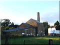
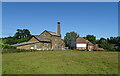
3
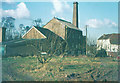
Tonge Mill in 1969
Taken from Scraps Hill. The mill dates back to 450 AD when the Saxons Hengist and Horsa joined forces. Hengist settled at Tonge and became the first king of Kent. The mill has seen 300 years of flour milling.
Image: © John Baker
Taken: Unknown
0.12 miles
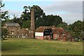
5
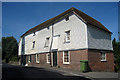
Mill House, Church Road, Tonge, Kent
Built 1759.
Grade II listed.
Image: © Oast House Archive
Taken: 19 Aug 2009
0.13 miles
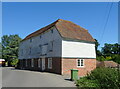
6
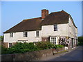
Weather-boarded house, Tonge
Historic house by the millstream. It sits opposite the old Tonge Mill.
Image: © Colin Smith
Taken: 29 Apr 2007
0.14 miles