IMAGES TAKEN NEAR TO
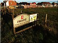
The Saltings, SITTINGBOURNE, ME9 8UU
Introduction
This page details the photographs taken nearby to The Saltings, ME9 8UU by members of the Geograph project.
The Geograph project started in 2005 with the aim of publishing, organising and preserving representative images for every square kilometre of Great Britain, Ireland and the Isle of Man.

There are currently over 7.5m images from over14,400 individuals and you can help contribute to the project by visiting https://www.geograph.org.uk
Image Map
Images are licensed for reuse under creativecommons.org/licenses/by-sa/2.0
Notes
- Clicking on the map will re-center to the selected point.
- The higher the marker number, the further away the image location is from the centre of the postcode.
Image Listing (32 Images Found)
Images are licensed for reuse under creativecommons.org/licenses/by-sa/2.0
Image
Details
Distance
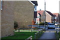
1
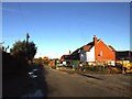
Football pitch, School Lane
Since I last photographed this Image, a hedge has been planted along the base of the fence and private property notices attached to it.
Image: © John Baker
Taken: 2 Apr 2017
0.04 miles
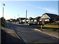
2
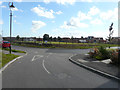
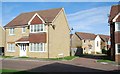
Football pitch, School Lane
Last September, the ground beyond Image was surrounded by a temporary security fence, which has since been replaced by a permanent-looking fence, seen from a slightly different location.
Image: © John Baker
Taken: 27 Sep 2015
0.05 miles
3
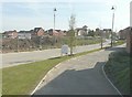
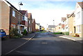
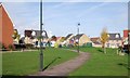
Holly Blue Drive, Iwade Meadows
A development of 2, 3 and 4 bedroom homes http://www.hillreed.co.uk/developments/iwade situated to the south of School Lane. Planning permission was granted by Swale Borough Council’s under application number SW/08/1127 for the “development of housing, employment (up to 3000 square metres), public open space and pavilion (up to 110 square metres), with access from School Lane and Sheppey Way, including roads, cycle paths, footpaths, stream crossings, landscaping and ancillary works”. The location was given as land adjacent (to) Coleshall Farm, Sheppey Way.
Image: © John Baker
Taken: 28 Sep 2014
0.09 miles