IMAGES TAKEN NEAR TO
Sharfleet Crescent, SITTINGBOURNE, ME9 8UQ
Introduction
This page details the photographs taken nearby to Sharfleet Crescent, ME9 8UQ by members of the Geograph project.
The Geograph project started in 2005 with the aim of publishing, organising and preserving representative images for every square kilometre of Great Britain, Ireland and the Isle of Man.

There are currently over 7.5m images from over14,400 individuals and you can help contribute to the project by visiting https://www.geograph.org.uk
Image Map
Images are licensed for reuse under creativecommons.org/licenses/by-sa/2.0
Notes
- Clicking on the map will re-center to the selected point.
- The higher the marker number, the further away the image location is from the centre of the postcode.
Image Listing (30 Images Found)
Images are licensed for reuse under creativecommons.org/licenses/by-sa/2.0
Image
Details
Distance
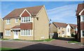
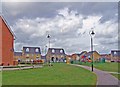
1
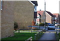
New housing at Iwade
Iwade expanded rapidly. The housing seen here is not yet marked on the Ordnance Survey Landranger map.
Image: © Richard Dorrell
Taken: 29 Mar 2008
0.03 miles
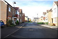
5
New housing estate in Iwade
This part of the estate has been built, but is not yet on the Landranger OS map.
On the "green" in the photograph is a deserted children's playground - and this was mid morning on a Saturday. No doubt all the local children were too busy sitting at their computer games to be out in the fresh air...
Image: © Richard Dorrell
Taken: 29 Mar 2008
0.10 miles
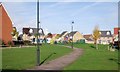
10
Football pitch, School Lane
Since I last photographed this Image, a hedge has been planted along the base of the fence and private property notices attached to it.
Image: © John Baker
Taken: 2 Apr 2017
0.12 miles