IMAGES TAKEN NEAR TO
Raspberry Hill Lane, SITTINGBOURNE, ME9 8SN
Introduction
This page details the photographs taken nearby to Raspberry Hill Lane, ME9 8SN by members of the Geograph project.
The Geograph project started in 2005 with the aim of publishing, organising and preserving representative images for every square kilometre of Great Britain, Ireland and the Isle of Man.

There are currently over 7.5m images from over14,400 individuals and you can help contribute to the project by visiting https://www.geograph.org.uk
Image Map
Images are licensed for reuse under creativecommons.org/licenses/by-sa/2.0
Notes
- Clicking on the map will re-center to the selected point.
- The higher the marker number, the further away the image location is from the centre of the postcode.
Image Listing (21 Images Found)
Images are licensed for reuse under creativecommons.org/licenses/by-sa/2.0
Image
Details
Distance
1
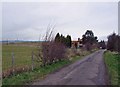
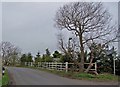
Track to Chetney Cottages
The track continues onto Chetney Marshes, part of which can be seen to the left of the trees.
Image: © Richard Dorrell
Taken: 24 Mar 2008
0.02 miles
2
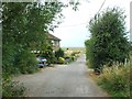
Chetney Cottages, Raspberry Hill Lane, near Iwade
Image: © Chris Whippet
Taken: 5 Aug 2015
0.03 miles
4
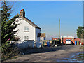
Willow Cottages (off Raspberry Hill Lane)
Image: © Mike Quinn
Taken: 30 Nov 2016
0.10 miles
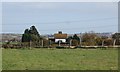
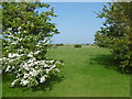
5
Willows at Willow Cottages
Willow Cottages stand on this corner of Raspberry Hill Lane, with a large willow tree either end of the garden.
Image: © Richard Dorrell
Taken: 24 Mar 2008
0.10 miles
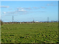
6
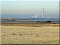
Farmland east of Bedlams Bottom
Looking WNW past one of the rotting hulks at Bedlams Bottom towards Kingsnorth Power Station in Image See also Image (photographed by Stephen Richards).
Image: © Mike Quinn
Taken: 30 Nov 2016
0.15 miles
8
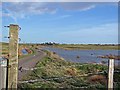
Towards Chetney Cottages
Taken from a gate in the track, Chetney Cottages are among the trees on the horizon. The water in the photograph is not shown on the Ordnance Survey map, so I presume it dries up in the summer.
Image: © Richard Dorrell
Taken: 1 Apr 2008
0.16 miles
9
The Sheppey Crossing from Raspberry Hill
This view is from the delightful path leading down from Raspberry Hill Lane at the top of Raspberry Hill down to the saltings and shipwrecks at Bedlams Bottom. The new Sheppey Crossing can be seen in the distance.
Image: © Marathon
Taken: 28 May 2016
0.16 miles
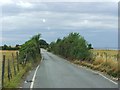
10
View from Raspberry Hill Lane
The flat landscape to either side of the Swale.
Image: © Robin Webster
Taken: 16 Feb 2014
0.19 miles