IMAGES TAKEN NEAR TO
Featherbed Lane, SITTINGBOURNE, ME9 8RA
Introduction
This page details the photographs taken nearby to Featherbed Lane, ME9 8RA by members of the Geograph project.
The Geograph project started in 2005 with the aim of publishing, organising and preserving representative images for every square kilometre of Great Britain, Ireland and the Isle of Man.

There are currently over 7.5m images from over14,400 individuals and you can help contribute to the project by visiting https://www.geograph.org.uk
Image Map
Images are licensed for reuse under creativecommons.org/licenses/by-sa/2.0
Notes
- Clicking on the map will re-center to the selected point.
- The higher the marker number, the further away the image location is from the centre of the postcode.
Image Listing (17 Images Found)
Images are licensed for reuse under creativecommons.org/licenses/by-sa/2.0
Image
Details
Distance
1
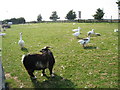
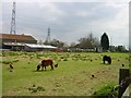
Animals at Iwade Farm Shop, Iwade, Kent
Image: © Oast House Archive
Taken: 21 Sep 2008
0.04 miles
2
Featherbed Farmyard
Farm shop, garden centre, pet food and farmyard animals are all on offer here with free-range chickens, geese, goats and ponies.
Image: © Penny Mayes
Taken: 16 Apr 2005
0.05 miles
3
Partly-constructed road into Iwade Meadows
This is the same Image but looking southwest towards the trees, that mark the road to Coleshall Farm. The development is described in Swale Borough Council’s planning application SW/08/1127 as the “development of housing, employment (up to 3000 square metres), public open space and pavilion (up to 110 square metres), with access from School Lane and Sheppey Way, including roads, cycle paths, footpaths, stream crossings, landscaping and ancillary works”. The location was given as land adjacent (to) Coleshall Farm, Sheppey Way.
Image: © John Baker
Taken: 9 Oct 2016
0.12 miles
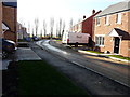
4
Partly-constructed road into Iwade Meadows
The nearer houses have been completed but those, in the distance, are still under construction. The development is described in Swale Borough Council’s planning application SW/08/1127 as the “development of housing, employment (up to 3000 square metres), public open space and pavilion (up to 110 square metres), with access from School Lane and Sheppey Way, including roads, cycle paths, footpaths, stream crossings, landscaping and ancillary works”. The location was given as land adjacent (to) Coleshall Farm, Sheppey Way.
Image: © John Baker
Taken: 9 Oct 2016
0.12 miles
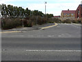
5
Green Oak Crescent, Iwade Meadows
This road is part of the development for which planning permission was granted by Swale Borough Council’s under application number SW/08/1127 as the “development of housing, employment (up to 3000 square metres), public open space and pavilion (up to 110 square metres), with access from School Lane and Sheppey Way, including roads, cycle paths, footpaths, stream crossings, landscaping and ancillary works”. The location was given as land adjacent (to) Coleshall Farm, Sheppey Way.
Image: © John Baker
Taken: 17 Jan 2017
0.13 miles
6
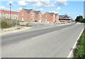
Houses under construction, Sheppey Way
The development of this site is described in Swale Borough Council’s planning application SW/08/1127 as the “development of housing, employment (up to 3000 square metres), public open space and pavilion (up to 110 square metres), with access from School Lane and Sheppey Way, including roads, cycle paths, footpaths, stream crossings, landscaping and ancillary works”. The location was given as Land adjacent Coleshall Farm, Sheppey Way. The houses are being built by Persimmon Homes and the development will be known as Iwade Meadows.
Image: © John Baker
Taken: 27 Sep 2015
0.14 miles
7
Peach Blossom Drive, Iwade Meadows
Compared with Image, the road has been given a name in the meantime, although further houses are under construction. Planning permission has been granted by Swale Borough Council under application number SW/08/1127 for the “development of housing, employment (up to 3000 square metres), public open space and pavilion (up to 110 square metres), with access from School Lane and Sheppey Way, including roads, cycle paths, footpaths, stream crossings, landscaping and ancillary works”. The location was given as land adjacent (to) Coleshall Farm, Sheppey Way.
Image: © John Baker
Taken: 9 Oct 2016
0.14 miles
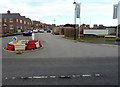
8
Peach Blossom Drive, Iwade Meadows
Compared with Image, the makeshift traffic island has been replaced with a proper traffic island. There seems to have been little, further building construction to the right side of the road. This road is part of the development for which planning permission was granted by Swale Borough Council’s under application number SW/08/1127 as the “development of housing, employment (up to 3000 square metres), public open space and pavilion (up to 110 square metres), with access from School Lane and Sheppey Way, including roads, cycle paths, footpaths, stream crossings, landscaping and ancillary works”. The location was given as land adjacent (to) Coleshall Farm, Sheppey Way.
Image: © John Baker
Taken: 17 Jan 2017
0.14 miles
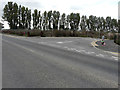
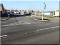
9
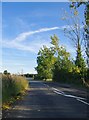
Grovehurst Road, south of Iwade
From the roundabout ahead there are links to the A249 Sheppey-Maidstone road.
Image: © Stefan Czapski
Taken: 13 Aug 2016
0.14 miles
10
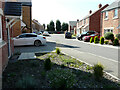
Green Oak Crescent, Iwade Meadows
This was Image before the houses at the far end had been built.
Image: © John Baker
Taken: 16 Sep 2021
0.15 miles