IMAGES TAKEN NEAR TO
Howt Green, Sheppey Way, SITTINGBOURNE, ME9 8QT
Introduction
This page details the photographs taken nearby to Howt Green, Sheppey Way, ME9 8QT by members of the Geograph project.
The Geograph project started in 2005 with the aim of publishing, organising and preserving representative images for every square kilometre of Great Britain, Ireland and the Isle of Man.

There are currently over 7.5m images from over14,400 individuals and you can help contribute to the project by visiting https://www.geograph.org.uk
Image Map
Images are licensed for reuse under creativecommons.org/licenses/by-sa/2.0
Notes
- Clicking on the map will re-center to the selected point.
- The higher the marker number, the further away the image location is from the centre of the postcode.
Image Listing (21 Images Found)
Images are licensed for reuse under creativecommons.org/licenses/by-sa/2.0
Image
Details
Distance
2
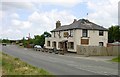
Dancing Dog Saloon
Formerly known as the Halfway, this pub lies on the old Sheppey Way near the charmingly named Nether Toes and was presumably half way between the A2 at Sittingbourne and the Isle of Sheppey.
Image: © Penny Mayes
Taken: 21 May 2005
0.06 miles
3
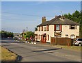
The Dancing Dog Saloon, Howt Green
In the days when this road was the A249, this was a pub known as The Halfway. It now flies the Confederate flag.
Image: © Stefan Czapski
Taken: 13 Aug 2016
0.07 miles
4
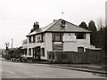
Dancing Dog Saloon, near Bobbing
Formerly known as The Halfway, this pub now has a Country and Western theme.
Image: © Chris Whippet
Taken: 23 Feb 2010
0.08 miles
5
Howt Green Farm
This shed is closely connected to the fruit growing business, as evidenced by the stacks of wooden crates for transporting fruit. A footpath leads through the metal gate and into acres of newly planted orchards. See Image
Image: © Richard Dorrell
Taken: 29 Mar 2008
0.10 miles
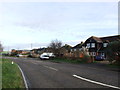
7
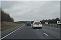
The old A249 at Nether Toes
Until the 1990s this was the main road to the port of Sheerness - which meant a stream of HGVs rolled through the villages of Bobbing and Iwade. I used to drive through pretty frequently, without ever noticing the name 'Nether Toes' on the map. A local landmark (up ahead, round the bend) was a filling station called Point Pheasant - long since gone, robbed of its passing trade.
Richard Dorrell identifies the industrial site by the bend of the road as the FloPlast factory: http://www.geograph.org.uk/photo/742702
Image: © Stefan Czapski
Taken: 4 Aug 2018
0.12 miles
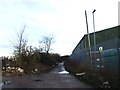
8
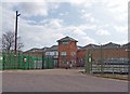
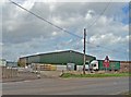
Entrance to FloPlast factory
Founded in 1991, FloPlast has established itself as a leading manufacturer and supplier of Plastic Building and Plumbing systems in the UK.
This entrance is off Sheppey Way.
Image: © Richard Dorrell
Taken: 29 Mar 2008
0.15 miles
9
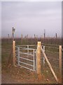
Kissing Gate near Floplast Factory
Leads to School Lane, near Culnells Farm, goes through a large orchard before two fields.
Image: © David Anstiss
Taken: 1 Jan 2006
0.17 miles