IMAGES TAKEN NEAR TO
School Lane, SITTINGBOURNE, ME9 8QJ
Introduction
This page details the photographs taken nearby to School Lane, ME9 8QJ by members of the Geograph project.
The Geograph project started in 2005 with the aim of publishing, organising and preserving representative images for every square kilometre of Great Britain, Ireland and the Isle of Man.

There are currently over 7.5m images from over14,400 individuals and you can help contribute to the project by visiting https://www.geograph.org.uk
Image Map
Images are licensed for reuse under creativecommons.org/licenses/by-sa/2.0
Notes
- Clicking on the map will re-center to the selected point.
- The higher the marker number, the further away the image location is from the centre of the postcode.
Image Listing (11 Images Found)
Images are licensed for reuse under creativecommons.org/licenses/by-sa/2.0
Image
Details
Distance
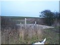
1
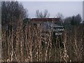
Unusual Collection in Culnells Farm
Seen on footpath to Stickfast Lane from School Lane.
Image: © David Anstiss
Taken: 1 Jan 2006
0.06 miles
2
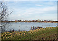
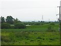
Reservoir near Culnells
I innocently strayed off the unsignposted public footpath to find myself alongside this large reservoir. It is popular with a variety of waterfowl, and has many fishing stations, though fishing rights are restricted. See also Image
Image: © Richard Dorrell
Taken: 27 Jan 2008
0.09 miles
3
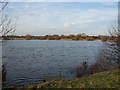
Reservoir near Culnells
Having strayed from the unsignposted public footpath, I was probably trespassing to take this picture. See also Image
Image: © Richard Dorrell
Taken: 27 Jan 2008
0.09 miles
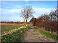
4
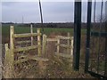
Footpath junction on School Lane
Path heading right over stile beside gate, leads through Culnells Farm, heading to Stickfast Lane near Cambray Farm. Black gates are farm entrance on road. Path on left, over two stiles !! leads to Sheppey Way, Howt Green near Pub.
Image: © David Anstiss
Taken: 1 Jan 2006
0.10 miles
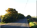
5
Track towards Culnells
"Culnells" is former farm buildings with planning for light industrial use. There were a lot of dogs barking behind a fence, so as I had Basil with me, I didn't go too close. The footpath is not waymarked.
Image: © Richard Dorrell
Taken: 27 Jan 2008
0.12 miles
6
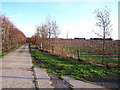
Track between orchards
This concrete farm track separates the young apple tree orchard on the right from an orchard of older trees behind the hedge on the left.
Image: © Richard Dorrell
Taken: 27 Jan 2008
0.15 miles
8
Footbridge across stream on footpath
Stream separates two fields. Footpath leads from Sheppey Way to School Lane, near Culnells Farm.
Image: © David Anstiss
Taken: 1 Jan 2006
0.20 miles
9
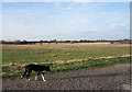
Big empty field
This view is looking north west from the track to Culnells. Basil is looking a bit weary. Directly behind me is Image
Image: © Richard Dorrell
Taken: 27 Jan 2008
0.21 miles
10
Reservoir near Iwade
This is one of few major features in this square but as it is used for private fishing it's very hard to get a close shot of it. Looking southish, the crop is beans.
Image: © Penny Mayes
Taken: 1 Jun 2005
0.22 miles