IMAGES TAKEN NEAR TO
Munsgore Lane, SITTINGBOURNE, ME9 8JU
Introduction
This page details the photographs taken nearby to Munsgore Lane, ME9 8JU by members of the Geograph project.
The Geograph project started in 2005 with the aim of publishing, organising and preserving representative images for every square kilometre of Great Britain, Ireland and the Isle of Man.

There are currently over 7.5m images from over14,400 individuals and you can help contribute to the project by visiting https://www.geograph.org.uk
Image Map
Images are licensed for reuse under creativecommons.org/licenses/by-sa/2.0
Notes
- Clicking on the map will re-center to the selected point.
- The higher the marker number, the further away the image location is from the centre of the postcode.
Image Listing (4 Images Found)
Images are licensed for reuse under creativecommons.org/licenses/by-sa/2.0
Image
Details
Distance
1
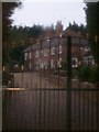
Munsgrove House
On unnamed road near Munsgrove Farm, Oad Street
Image: © David Anstiss
Taken: 16 Jan 2009
0.05 miles
2
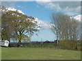
View at Munsgore Farm
This is the view from the footpath from Oad Street and Sunnyhill Road as it approaches Munsgore Farm. The Isle of Sheppey is on the horizon to the left of the pylon while Whitstable is behind the pylon. There are a great number of horses in this area.
Image: © Marathon
Taken: 17 Apr 2016
0.12 miles
3
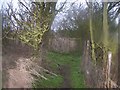
Footpath junction near Pond Farm
Path from Munsgrove Farm, divides at this point. Path on left leads to Pond Farm Road, near Borden. Path on right heads to unnamed road near Eyehorn Hatch Farm.
Image: © David Anstiss
Taken: 16 Jan 2009
0.16 miles
4

Eyehorn Hatch Farmhouse, Borden
On Sunnyhill Road.
Image: © pam fray
Taken: 26 Jul 2016
0.22 miles