IMAGES TAKEN NEAR TO
The Street, SITTINGBOURNE, ME9 8JN
Introduction
This page details the photographs taken nearby to The Street, ME9 8JN by members of the Geograph project.
The Geograph project started in 2005 with the aim of publishing, organising and preserving representative images for every square kilometre of Great Britain, Ireland and the Isle of Man.

There are currently over 7.5m images from over14,400 individuals and you can help contribute to the project by visiting https://www.geograph.org.uk
Image Map
Images are licensed for reuse under creativecommons.org/licenses/by-sa/2.0
Notes
- Clicking on the map will re-center to the selected point.
- The higher the marker number, the further away the image location is from the centre of the postcode.
Image Listing (67 Images Found)
Images are licensed for reuse under creativecommons.org/licenses/by-sa/2.0
Image
Details
Distance
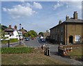
1
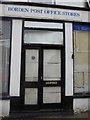
Borden Post Office Stores, The Street
It is looking even sadder than it did eight years ago when I last visited and I gather it has been closed for about 10 years. There are now no shops in Borden; just a pub and a church.
Image: © pam fray
Taken: 26 Jul 2016
0.01 miles
2
Another one bites the dust
A sad and all too common sight in villages now, this post office store has closed down.
Image: © pam fray
Taken: 30 Jul 2008
0.01 miles
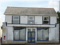
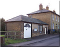
3
Borden Post Office Stores
A sign of the times - in spite of its location in an historic and picturesque Kent village, the local Post Office and stores has closed down.
Image: © Richard Dorrell
Taken: 12 Jan 2008
0.02 miles
4
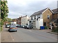
The Street, Borden
Borden's old Post Office is on the right.
Image: © Chris Whippet
Taken: 13 May 2016
0.02 miles
5
Borden: The Street, seen from the churchyard
The building on the right (Forge House and Barrow House) has an urban bulk to it that seems at odds with the village context. On the left, the pub is the Maypole - much more in keeping with the scale of the old village centre.
The village has expanded (in various directions) in the last thirty years or so, but I saw posters in support of a campaign to resist further development.
Notice the traffic cones - witches' hats - often a feature of village churchyards these days.
Image: © Stefan Czapski
Taken: 4 Aug 2018
0.03 miles
6
Stable block? - No, Blacksmith's forge
Standing alongside Barrow House Image and clearly built at the same time, this building was surely originally something to do with horses, though looks too small to be a coach house. Any ideas anyone? Incidentally, the noticeboard on the building is a bus timetable - the local buses stop here!
I am grateful to site visitor John Crunden who has been in touch with the following information -
"This building was the local blacksmith's forge. Horses were taken in at the large door for shoeing, and the circle on the ground in front of the window was where cartwheels were repaired and new ones built. When the wooden wheels were finished a large iron ring was heated up on the forge, just inside the small door, and then hammered onto the rim".
Image: © Richard Dorrell
Taken: 12 Jan 2008
0.03 miles
8
Steps to The Playstool and footpath
The Playstool is Borden village's recreation ground on The Street. The footpath crosses the green to lead to Auckland Drive, Sittingbourne.
Image: © David Anstiss
Taken: 14 Jan 2009
0.04 miles
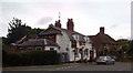
9

The Maypole public house, Borden
The Maypole is the only pub in Borden.
Image: © Richard Dorrell
Taken: 12 Jan 2008
0.04 miles
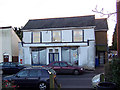
10
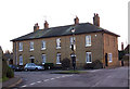
Barrow House, Borden
This substantial pair of houses are located in the centre of the village. The house on the right is now named Barrow House. See Image for more.
Image: © Richard Dorrell
Taken: 12 Jan 2008
0.04 miles