IMAGES TAKEN NEAR TO
Borden Lane, SITTINGBOURNE, ME9 8HP
Introduction
This page details the photographs taken nearby to Borden Lane, ME9 8HP by members of the Geograph project.
The Geograph project started in 2005 with the aim of publishing, organising and preserving representative images for every square kilometre of Great Britain, Ireland and the Isle of Man.

There are currently over 7.5m images from over14,400 individuals and you can help contribute to the project by visiting https://www.geograph.org.uk
Image Map
Images are licensed for reuse under creativecommons.org/licenses/by-sa/2.0
Notes
- Clicking on the map will re-center to the selected point.
- The higher the marker number, the further away the image location is from the centre of the postcode.
Image Listing (13 Images Found)
Images are licensed for reuse under creativecommons.org/licenses/by-sa/2.0
Image
Details
Distance
2
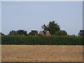
Cowls of Ferndale Oast, Sittingbourne
As seen from Starveacre Lane.
Image: © David Anstiss
Taken: 6 Sep 2012
0.14 miles
3
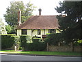
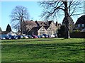
Posiers, Borden Lane
Grade II listed C15 four bay Wealden hall house.
Image: © Oast House Archive
Taken: 17 Sep 2010
0.15 miles
4
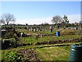
Allotments on Riddles Road
The building just visible on the left is the Adult Education College.
Image: © Penny Mayes
Taken: 21 Apr 2005
0.17 miles
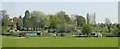
6
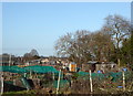
Allotments on Riddles Road
Plenty of activity here on a sunny March morning.
Image: © Penny Mayes
Taken: 12 Mar 2007
0.19 miles
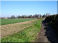
7
Riddles Road Allotments, Borden
Viewed from Starveacre Lane.
Image: © pam fray
Taken: 22 Dec 2016
0.20 miles
8
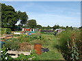
Riddles Road Allotments, Sittingbourne
Large block of allotments beside Riddles Road, seen from Starveacre Lane (track).
Image: © David Anstiss
Taken: 6 Sep 2012
0.20 miles
9
Sittingbourne Adult Education College
I'm told by Philip Pankhurst, and old maps confirm, this, built at the end of the 19th century, was the original Borden Grammar School. It became the Kent Farm Institute when the school moved to its current premises in Central Avenue (Image) in the 1920s. It later became a teacher training college. In recent years part of the playing fields have been sold off for building development (houses on right of shot) and the fencing round the old tennis courts has been removed.
Image: © Penny Mayes
Taken: 12 Mar 2007
0.22 miles
10
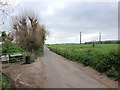
Starveacre Lane
Contrary to appearances, this lane is surfaced at this point but degenerates into an even muddier track behind the photographer. The wheat field on the left runs down to the allotments on Riddles Road http://www.geograph.org.uk/photo/364027 and backs onto gardens on Borden Lane out of shot to the left. The large building on the right is the Adult Education College in the next square.
Image: © Penny Mayes
Taken: 12 Mar 2007
0.22 miles