IMAGES TAKEN NEAR TO
Primrose Lane, SITTINGBOURNE, ME9 8EH
Introduction
This page details the photographs taken nearby to Primrose Lane, ME9 8EH by members of the Geograph project.
The Geograph project started in 2005 with the aim of publishing, organising and preserving representative images for every square kilometre of Great Britain, Ireland and the Isle of Man.

There are currently over 7.5m images from over14,400 individuals and you can help contribute to the project by visiting https://www.geograph.org.uk
Image Map
Images are licensed for reuse under creativecommons.org/licenses/by-sa/2.0
Notes
- Clicking on the map will re-center to the selected point.
- The higher the marker number, the further away the image location is from the centre of the postcode.
Image Listing (136 Images Found)
Images are licensed for reuse under creativecommons.org/licenses/by-sa/2.0
Image
Details
Distance
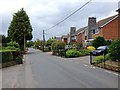
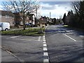
2
Primrose Lane, Bredgar
Before the M2 motorway was built in the 1960s the road followed the line of the right-hand fork. The motorway cut the northern edge of the village off and that road now comes to a dead end at the motorway cutting. The new route, to the left, sweeps around over the M2 and rejoins the old road at Rookery Close.
Image: © Penny Mayes
Taken: 1 Mar 2006
0.03 miles
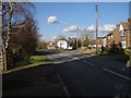
3
Bredgar Garage
Looking south up Primrose Lane towards the centre of the village. The garage is one of the four remaining retail businesses in the village.
Image: © Penny Mayes
Taken: 1 Mar 2006
0.05 miles
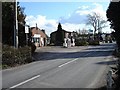
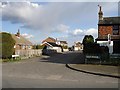
5
Primrose Lane, Bredgar
Looking south. The road to the left is the original route of Primrose Lane at this point before the M2 motorway was built through the northern edge of the village and the road was diverted over the new bridge. The concrete truncated cones on the corners of the grass triangle are WWII tank traps. See also http://www.geograph.org.uk/photo/133448
Image: © Penny Mayes
Taken: 1 Mar 2006
0.08 miles
6
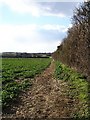
Rape field, Bredgar
Just a few years ago these were apple orchards but "set-aside" crops seem to have taken over these days. The western edge of the square is roughly where the fence-line meets the hedge on the right. The far left-to-right hedgeline is Wrens Road.
Image: © Penny Mayes
Taken: 1 Mar 2006
0.08 miles
7
Medlar Close, Bredgar
From the junction with Primrose Lane, looking east.
Image: © Penny Mayes
Taken: 1 Mar 2006
0.10 miles
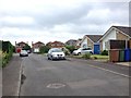
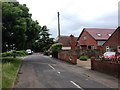
9
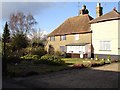
Nether End, Bredgar
These cottages used to stand on the main road before the M2 motorway was built in the 1960s. See also http://www.geograph.org.uk/photo/133448 and http://www.geograph.org.uk/photo/133490
Image: © Penny Mayes
Taken: 1 Mar 2006
0.10 miles
10
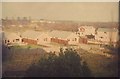
Medlar Close, Bredgar in 1971
As seen from the second floor of Bredgar House Image from the window at the far left. Unfortunately I did not identify the photo with a date, although I have given it the month as December due to the lack of leaves on the trees nearest to the camera. I have not been able to find much of relevance for Medlar Close on the internet so the submission could be subject to an update…
Image: © John Baker
Taken: Unknown
0.11 miles