IMAGES TAKEN NEAR TO
SITTINGBOURNE, ME9 8AG
Introduction
This page details the photographs taken nearby to ME9 8AG by members of the Geograph project.
The Geograph project started in 2005 with the aim of publishing, organising and preserving representative images for every square kilometre of Great Britain, Ireland and the Isle of Man.

There are currently over 7.5m images from over14,400 individuals and you can help contribute to the project by visiting https://www.geograph.org.uk
Image Map
Images are licensed for reuse under creativecommons.org/licenses/by-sa/2.0
Notes
- Clicking on the map will re-center to the selected point.
- The higher the marker number, the further away the image location is from the centre of the postcode.
Image Listing (5 Images Found)
Images are licensed for reuse under creativecommons.org/licenses/by-sa/2.0
Image
Details
Distance
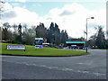
2
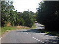
Broadoak Road
Leading past Kent Science Park.
Image: © Oast House Archive
Taken: 19 Aug 2009
0.09 miles
3
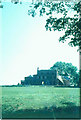
Woodstock House, 1971
Woodstock House was built in the early 1780s by Abraham Chambers. It was requisitioned by the Government during both world wars. Shortly after the estate became Shell property in 1945, land to the north of Broad Oak Road, and with it Woodstock House, was requisitioned by the Kent Farm Institute. For some time the building was used by Kent Fire Brigade as a practice site. Not surprisingly it became structurally unsound. Soon after this picture was taken, it was demolished.
Image: © John Baker
Taken: Unknown
0.17 miles
4
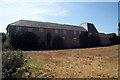
Oast House at Oakwood Farm, Sittingbourne, Kent
Image: © Oast House Archive
Taken: 19 Aug 2009
0.22 miles
5
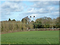
Three chimneys
On the Kent Science Park.
Image: © Robin Webster
Taken: 4 Apr 2015
0.25 miles