IMAGES TAKEN NEAR TO
Old House Lane, SITTINGBOURNE, ME9 7SN
Introduction
This page details the photographs taken nearby to Old House Lane, ME9 7SN by members of the Geograph project.
The Geograph project started in 2005 with the aim of publishing, organising and preserving representative images for every square kilometre of Great Britain, Ireland and the Isle of Man.

There are currently over 7.5m images from over14,400 individuals and you can help contribute to the project by visiting https://www.geograph.org.uk
Image Map
Images are licensed for reuse under creativecommons.org/licenses/by-sa/2.0
Notes
- Clicking on the map will re-center to the selected point.
- The higher the marker number, the further away the image location is from the centre of the postcode.
Image Listing (5 Images Found)
Images are licensed for reuse under creativecommons.org/licenses/by-sa/2.0
Image
Details
Distance
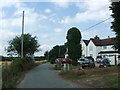
2
Sweepstakes Farm, Hartlip
Looking WNW from Old House Lane.
Image: © Penny Mayes
Taken: 14 Feb 2006
0.13 miles
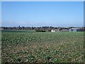
3
Footpath and stile toward Bull Lane
Footpath from Church Wood/Wormdale Hill.
Nunfield Farm on right of photo.
Image: © David Anstiss
Taken: 27 Nov 2008
0.15 miles
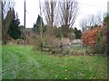
4
Nunfield House
On Bull Lane. Has eco-friendly wind-turbine in horse paddocks behind house facing M2 Motorway.
Image: © David Anstiss
Taken: 27 Nov 2008
0.16 miles
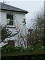
5
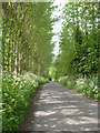
A poplar lined section of Bull Lane
Approaching the bend in the road which takes it to Lower Hartlip.
Image: © pam fray
Taken: 10 May 2009
0.16 miles