IMAGES TAKEN NEAR TO
Charlotte Court, High Street, SITTINGBOURNE, ME9 7FQ
Introduction
This page details the photographs taken nearby to Charlotte Court, High Street, ME9 7FQ by members of the Geograph project.
The Geograph project started in 2005 with the aim of publishing, organising and preserving representative images for every square kilometre of Great Britain, Ireland and the Isle of Man.

There are currently over 7.5m images from over14,400 individuals and you can help contribute to the project by visiting https://www.geograph.org.uk
Image Map
Images are licensed for reuse under creativecommons.org/licenses/by-sa/2.0
Notes
- Clicking on the map will re-center to the selected point.
- The higher the marker number, the further away the image location is from the centre of the postcode.
Image Listing (113 Images Found)
Images are licensed for reuse under creativecommons.org/licenses/by-sa/2.0
Image
Details
Distance
1
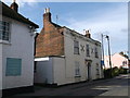
The Holme, Newington
Grade II listed house on Newington High Street.
See http://www.britishlistedbuildings.co.uk/en-176168-the-holme-newington-kent for more details.
Image: © David Anstiss
Taken: 6 Sep 2012
0.01 miles
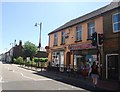
2
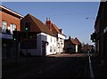
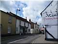
High Street, Newington
Looking east from near Bull Lane.
Image: © Penny Mayes
Taken: 29 Jan 2006
0.01 miles
3
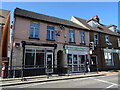
Newington Pharmacy and Post Office
On High Street.
Image: © JThomas
Taken: 22 Jun 2022
0.01 miles
4
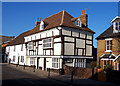
George House, Newington
A 17th Century Town House on the north side of Newington High Street. The house was in use as a pub when severely damaged by a fire in February 1998. The house stood derelict for several years, but has now been fully restored and converted into two private dwellings.
Image: © Richard Dorrell
Taken: 16 Dec 2007
0.02 miles
5
On the corner of High Street and Church Lane, Newington
High Street in Newington is route of the old Roman road Watling Street as followed by Chaucer. It was also once the route of the A2.
Image: © Marathon
Taken: 25 Apr 2015
0.02 miles
7
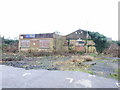
Newington Social Club
This building has been derelict for around five years now. Permission has been granted for its demolition with the possible erection of flats, but at the moment the site remains an untidy eyesore.
Image: © Chris Whippet
Taken: 23 Feb 2010
0.03 miles
8
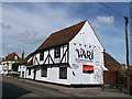
No 57 Newington High Street
Grade II listed pair of cottages that have been converted into a house and restaurant.
See http://www.britishlistedbuildings.co.uk/en-176173-57-high-street-newington-kent for more details.
Image: © David Anstiss
Taken: 6 Sep 2012
0.03 miles
9
High Street, Newington
This is the old Watling Street as followed by Chaucer. It was also once the route of the A2.
Image: © Marathon
Taken: 25 Apr 2015
0.03 miles
10
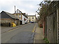
Church Lane in Newington
Looking southward to its junction with the A2
Image: © Peter Wood
Taken: 12 Feb 2016
0.03 miles