IMAGES TAKEN NEAR TO
Wetham Green, SITTINGBOURNE, ME9 7EY
Introduction
This page details the photographs taken nearby to Wetham Green, ME9 7EY by members of the Geograph project.
The Geograph project started in 2005 with the aim of publishing, organising and preserving representative images for every square kilometre of Great Britain, Ireland and the Isle of Man.

There are currently over 7.5m images from over14,400 individuals and you can help contribute to the project by visiting https://www.geograph.org.uk
Image Map
Images are licensed for reuse under creativecommons.org/licenses/by-sa/2.0
Notes
- Clicking on the map will re-center to the selected point.
- The higher the marker number, the further away the image location is from the centre of the postcode.
Image Listing (13 Images Found)
Images are licensed for reuse under creativecommons.org/licenses/by-sa/2.0
Image
Details
Distance
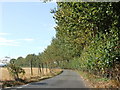
1
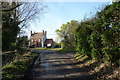
A lane from The Street, Upchurch, looking towards Poultry Farm
Image: © pam fray
Taken: 1 Dec 2009
0.09 miles
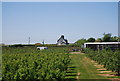
3
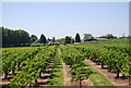
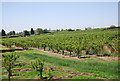
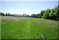
Orchards on the banks of the River Medway
Image: © N Chadwick
Taken: 23 May 2010
0.16 miles
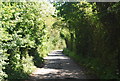
10
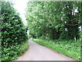
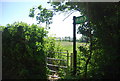
Saxon Shore Way heads to Upchurch
The OS map shows this area as orchards, sadly like so many they have been grubbed up.
Image: © N Chadwick
Taken: 23 May 2010
0.23 miles