IMAGES TAKEN NEAR TO
The Street, SITTINGBOURNE, ME9 7EU
Introduction
This page details the photographs taken nearby to The Street, ME9 7EU by members of the Geograph project.
The Geograph project started in 2005 with the aim of publishing, organising and preserving representative images for every square kilometre of Great Britain, Ireland and the Isle of Man.

There are currently over 7.5m images from over14,400 individuals and you can help contribute to the project by visiting https://www.geograph.org.uk
Image Map
Images are licensed for reuse under creativecommons.org/licenses/by-sa/2.0
Notes
- Clicking on the map will re-center to the selected point.
- The higher the marker number, the further away the image location is from the centre of the postcode.
Image Listing (84 Images Found)
Images are licensed for reuse under creativecommons.org/licenses/by-sa/2.0
Image
Details
Distance
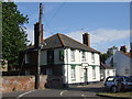
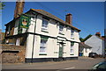
5
The Crown at Upchurch Public House
On junction of The Street and Forge Lane.
Brick wall on left belongs to St Mary's Churchyard.
Image: © David Anstiss
Taken: 16 Nov 2008
0.03 miles
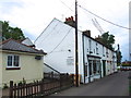
7
Terrys of Upchurch, fruit, vegetables and flowers
Image: © Nick Smith
Taken: 28 Sep 2009
0.03 miles
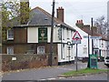
9
The Crown, The Street, Upchurch
Either the crown or the Crown at Upchurch, depends which sign you read.
Image: © N Chadwick
Taken: 23 May 2010
0.03 miles