IMAGES TAKEN NEAR TO
School Lane, SITTINGBOURNE, ME9 7ES
Introduction
This page details the photographs taken nearby to School Lane, ME9 7ES by members of the Geograph project.
The Geograph project started in 2005 with the aim of publishing, organising and preserving representative images for every square kilometre of Great Britain, Ireland and the Isle of Man.

There are currently over 7.5m images from over14,400 individuals and you can help contribute to the project by visiting https://www.geograph.org.uk
Image Map
Images are licensed for reuse under creativecommons.org/licenses/by-sa/2.0
Notes
- Clicking on the map will re-center to the selected point.
- The higher the marker number, the further away the image location is from the centre of the postcode.
Image Listing (73 Images Found)
Images are licensed for reuse under creativecommons.org/licenses/by-sa/2.0
Image
Details
Distance
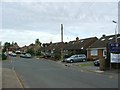
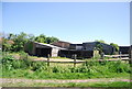
3
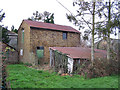
Barns at Lower Halstow
Halstow is a very rural village, as evidenced by these barns which stand among the houses and almost opposite the primary school.
Image: © Richard Dorrell
Taken: 26 Jan 2008
0.02 miles
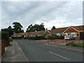
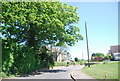
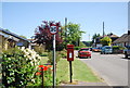
5
Cumberland Drive off School Lane, Lower Halstow
Image: © N Chadwick
Taken: 23 May 2010
0.03 miles
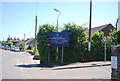
6
Postbox, corner of Cumberland Drive, Lower Halstow
Image: © N Chadwick
Taken: 23 May 2010
0.04 miles
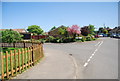
7
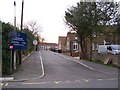
Entrance to Lower Halstow Primary School
The school is also a community sports and arts centre.
Image: © Richard Dorrell
Taken: 26 Jan 2008
0.04 miles