IMAGES TAKEN NEAR TO
Wormshill, SITTINGBOURNE, ME9 0TJ
Introduction
This page details the photographs taken nearby to ME9 0TJ by members of the Geograph project.
The Geograph project started in 2005 with the aim of publishing, organising and preserving representative images for every square kilometre of Great Britain, Ireland and the Isle of Man.

There are currently over 7.5m images from over14,400 individuals and you can help contribute to the project by visiting https://www.geograph.org.uk
Image Map
Images are licensed for reuse under creativecommons.org/licenses/by-sa/2.0
Notes
- Clicking on the map will re-center to the selected point.
- The higher the marker number, the further away the image location is from the centre of the postcode.
Image Listing (18 Images Found)
Images are licensed for reuse under creativecommons.org/licenses/by-sa/2.0
Image
Details
Distance
1

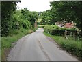
View from the lane north of Frinsted
Looking towards Bottom Pond with Bottom Pond Farm on the right.
Image: © pam fray
Taken: 10 Aug 2021
0.02 miles
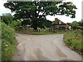
2
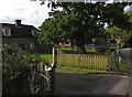
Bottom Pond, Kent
Cottage and oak tree at the junction in this hamlet north of Frinsted
Image: © Paul Harrop
Taken: 24 Sep 2015
0.06 miles
3

Wyatt Cottage, Wormshill
On the corner of Bottom Pond Road.
Image: © pam fray
Taken: 10 Aug 2021
0.06 miles
4
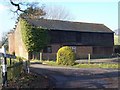
Unconverted Barn and Oast House
On junction of Bottom Pond Road (in front) and Bedmonton Lane (on left).
Oast House has no cowl.
Image: © David Anstiss
Taken: 29 Jan 2009
0.07 miles
5
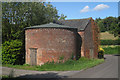
Unconverted Oast House at Bottom Pond Farm, Wormshill, Kent
Image: © Oast House Archive
Taken: 30 Jul 2009
0.07 miles
6

Bottom Pond Farm, Bottom Pond Road
West of the village of Milstead, near Wormshill. The round building is part of an unconverted oast house, consisting of a single round kiln missing the conical roof and cowl.
Image: © pam fray
Taken: 10 Aug 2021
0.07 miles

9
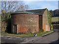
Unconverted Oast and Barn
On Bedmonton Lane junction with Bottom Pond Road.
Image: © David Anstiss
Taken: 29 Jan 2009
0.08 miles