IMAGES TAKEN NEAR TO
Kingsdown, SITTINGBOURNE, ME9 0RA
Introduction
This page details the photographs taken nearby to ME9 0RA by members of the Geograph project.
The Geograph project started in 2005 with the aim of publishing, organising and preserving representative images for every square kilometre of Great Britain, Ireland and the Isle of Man.

There are currently over 7.5m images from over14,400 individuals and you can help contribute to the project by visiting https://www.geograph.org.uk
Image Map
Images are licensed for reuse under creativecommons.org/licenses/by-sa/2.0
Notes
- Clicking on the map will re-center to the selected point.
- The higher the marker number, the further away the image location is from the centre of the postcode.
Image Listing (11 Images Found)
Images are licensed for reuse under creativecommons.org/licenses/by-sa/2.0
Image
Details
Distance
4
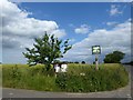
The village sign for Kingsdown
Kingsdown is a small hamlet and this is actually on the way out of it, at the junction of Kingsdown Road with Ludgate Road which comes in from the left here. A close up of the sign can be seen at https://www.geograph.org.uk/photo/6191559
Image: © Marathon
Taken: 21 Jun 2019
0.09 miles
5
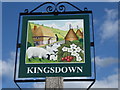
The village sign for Kingsdown
Kingsdown is a small hamlet and this is actually on the way out of it, at the junction of Kingsdown Road with Ludgate Road. Its setting can be seen at https://www.geograph.org.uk/photo/6191557 The sign shows a very idealised Kentish scene with sheep, cherries, oast houses, an old half-timbered house and the Downs - compare with the sign for nearby Lynsted https://www.geograph.org.uk/photo/6191511
Image: © Marathon
Taken: 21 Jun 2019
0.09 miles
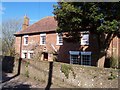
7
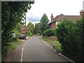
Hare Cottage
On access road in Hole Street Farm, off Kingsdown Road. A bridleway goes through the farm leading over the M2 Motorway to the Old Rectory.
Image: © David Anstiss
Taken: 24 Mar 2009
0.14 miles
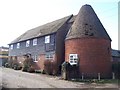
8
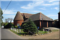
Oast House at Hole Street Farmhouse, Hole Street, Lynstead, Kent
Image: © Oast House Archive
Taken: 19 Aug 2009
0.14 miles
9
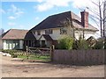
Hole Street Farm
Converted Oast House on Kingsdown Road. A bridlepath goes through the farm then over M2 Motorway to the Old Rectory.
Image: © David Anstiss
Taken: 24 Mar 2009
0.15 miles
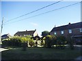
10
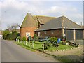
Hole Street Farm
A collection of old farm machinery displayed on the lawn.
Image: © Penny Mayes
Taken: 19 Apr 2005
0.16 miles