IMAGES TAKEN NEAR TO
Amherst Hill, GILLINGHAM, ME7 5BF
Introduction
This page details the photographs taken nearby to Amherst Hill, ME7 5BF by members of the Geograph project.
The Geograph project started in 2005 with the aim of publishing, organising and preserving representative images for every square kilometre of Great Britain, Ireland and the Isle of Man.

There are currently over 7.5m images from over14,400 individuals and you can help contribute to the project by visiting https://www.geograph.org.uk
Image Map
Images are licensed for reuse under creativecommons.org/licenses/by-sa/2.0
Notes
- Clicking on the map will re-center to the selected point.
- The higher the marker number, the further away the image location is from the centre of the postcode.
Image Listing (353 Images Found)
Images are licensed for reuse under creativecommons.org/licenses/by-sa/2.0
Image
Details
Distance
1
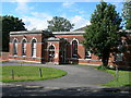
Nursery, Amherst Hill, Brompton
This was surely built as a military building of some sort, but I don't know what. It is now a nursery.
Image: © Danny P Robinson
Taken: 10 Aug 2008
0.02 miles
2
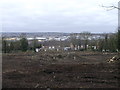
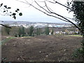
Development Land, Amherst Hill (4)
This large piece of land is between Khartoum Road (in the background) and Maxwell Road.
For ages it has been a patch of wildscrub and trees.
In the background is the River Medway and views towards Strood and Medway City Industrial Estate.
The land on the left, beyond the green fence is part of the Fort Amherst and the Great Lines Heritage Park.
Image: © David Anstiss
Taken: 1 Mar 2013
0.02 miles
3
Development Land, Amherst Hill (2)
This large piece of land is between Amherst Hill and Maxwell Road.
For ages it has been a patch of wildscrub and trees.
Image: © David Anstiss
Taken: 1 Mar 2013
0.03 miles
4
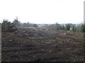
Development Land, Amherst Hill
This large piece of land is beside Amherst Hill and Maxwell Road.
For ages it has been a patch of wildscrub and trees.
In the background is the River Medway and views towards Rochester.
Image: © David Anstiss
Taken: 1 Mar 2013
0.03 miles
6
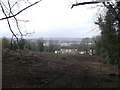
Development Land, Amherst Hill (3)
This large piece of land is between Khartoum Road (in the background) and Maxwell Road.
For ages it has been a patch of wildscrub and trees.
In the background is the River Medway and views towards Strood and Medway City Industrial Estate.
The land on the left, beyond the green fence is part of the Fort Amherst and the Great Lines Heritage Park.
Image: © David Anstiss
Taken: 1 Mar 2013
0.04 miles
8
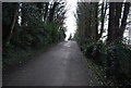
Maxwell Road, Brompton
As seen from the gates to the Great Lines Heritage Park near Fort Amherst.
Image: © David Anstiss
Taken: 23 Apr 2012
0.05 miles
9
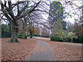
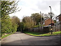
Park off Maxwell Road, Brompton
This is a small park. there are no signs that display a name, nor is one shown on any map I've seen. My guess is that it is owned by the Ministry of Defence, not the local council. To the left, behind the green fence, are some sunken fortifications -- this entire area is full of ditches, tunnels and other defensive positions built over many years.
Image: © Danny P Robinson
Taken: 18 Nov 2007
0.06 miles
10
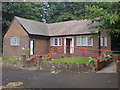
Garrison Church Hall, Maxwell Road
This is used by the church across the road Image and is also hired out for community activities or to other churches.
Image: © Danny P Robinson
Taken: 3 Aug 2008
0.06 miles