IMAGES TAKEN NEAR TO
Windsor Court, GILLINGHAM, ME7 4PQ
Introduction
This page details the photographs taken nearby to Windsor Court, ME7 4PQ by members of the Geograph project.
The Geograph project started in 2005 with the aim of publishing, organising and preserving representative images for every square kilometre of Great Britain, Ireland and the Isle of Man.

There are currently over 7.5m images from over14,400 individuals and you can help contribute to the project by visiting https://www.geograph.org.uk
Image Map (171 Images)


Leaflet Map data © OpenStreetMap
Images are licensed for reuse under creativecommons.org/licenses/by-sa/2.0
Notes
- Clicking on the map will re-center to the selected point.
- The higher the marker number, the further away the image location is from the centre of the postcode.
Image Listing (171 Images Found)
Images are licensed for reuse under creativecommons.org/licenses/by-sa/2.0
Image
Details
Distance
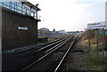
1
Gillingham Level Crossing
Picture taken from the footbridge Image A coastbound train has just left Gillingham Station and is headed towards the crossing. The road that crosses is called Ingram Road.
Image: © Danny P Robinson
Taken: 1 Jan 2008
0.01 miles
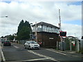
2
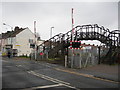
Footbridge by Gillingham Level Crossing
Picture taken on Ingram Road, looking north.
Image: © Danny P Robinson
Taken: 1 Jan 2008
0.01 miles
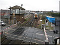
3
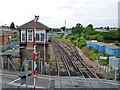
Signal box and trackwork west of Gillingham Level Crossing
The electrified siding on the right leads to a further non-electrified overgrown siding. From this the Chatham Dockyard Branch diverged, in this 2012 view the connection is still intact.
Image: © Robin Webster
Taken: 23 Jun 2012
0.02 miles
6
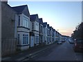
Windsor Road turns into Toledo Paddock
Windsor Road leads from Avondale road to Windsor Court (on left). Then Toledo Paddock leads to Gillingham Road. Windsor Court is recently built housing estate.
Image: © David Anstiss
Taken: 16 Jul 2009
0.03 miles
7
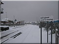
Snow covered railway lines in Gillingham
As seen from the level crossing near Ingram Road/Gillingham Road.
The railway line leads towards Gillingham Railway Station.
Due to the heavy snows and ice no trains are using the lines.
Image: © David Anstiss
Taken: 3 Dec 2010
0.04 miles
8
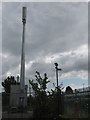
3G Mobile Phone Mast, beside Railway, Gillingham
This mast is at the end of Gillingham Railway Station carpark, beside the mainline running from Gillingham towards Rainham. The planning application for this mast was defeated by local opposition and the council, but was then appealed and granted by the High Courts. But St Mary's Catholic Primary School parents and friends are still campaigning to remove this mast.
Image: © David Anstiss
Taken: 19 Jul 2009
0.04 miles